Old Maps of Eyak, Cordova
Explore 9 old maps of Eyak, spanning from 1948 to today. These high-resolution historic maps reveal how streets, neighborhoods, landmarks, and natural features evolved over time — perfect for genealogy, metal detecting, research, and local history exploration.
What you can do with these maps:
- See how Eyak changed over time: Compare historical maps to modern-day views to trace roads, homesites, rail lines & more.
- View detailed metadata: Each map includes creators, publishers, year, scale, and archive source.
- Overlay maps with satellite & LiDAR: Visualize the past alongside modern tools to explore terrain & human change.
- Trusted historical sources: Maps sourced from the USGS, Library of Congress, and other archives.
- Access maps your way: View online, download high-res files, or order prints for personal or research use.
Start exploring old maps of Eyak to uncover forgotten places, hidden landmarks, and the deep history beneath your feet.
Eyak, Cordova maps
(9)- 1948 Map of Cordova, 1957 Print
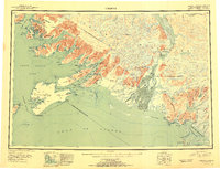
 1948 Cordova1957 Print · USGSCoastal Alaska in the late 1940s is defined by its deep-water inlets and the massive Copper River Delta. Genealogists and historians can trace old settlements like Katalla, Ellamar, and Nuchek alongside landmarks like the Cordova Airport.2 unique versions available
 - 1951 Map of Cordova
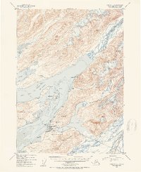
 1951 Cordova1951 Print · USGSThe Gulf of Alaska shoreline comes alive in the early fifties, detailing the intricate fjords and coastal settlements of Prince William Sound. Genealogists and historians can trace the Copper River and Northwestern RR and locate sites like Katalla, Ellamar, and Nuchek.3 unique versions available
 - 1951 Map of Cordova C-5, 1962 Print
 1951 Cordova C-51962 Print · USGSCordova and the surrounding Prince William Sound coast are captured here in the early fifties as the region's fishing and aviation infrastructure took shape. Researchers can trace local landmarks like the Eyak Cannery, the Landing Strip, and the early footprints of Orca and Mavis.4 unique versions available
 - 1953 Map of Cordova C-5, 1954 Print
 1953 Cordova C-51954 Print · USGSCordova and the Prince William Sound coastline are captured here in the early fifties as the local fishing and canning industries thrived. Researchers can trace the town footprint including the Cordova Airstrip, the Eyak Cannery, and landmarks like Mt Eyak.2 unique versions available
 - 1959 Map of Cordova, 1966 Print
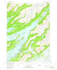
 1959 Cordova1966 Print · USGSCoastal life and the industrial legacy of the Copper River region are frozen in time on this mid-century survey of Prince William Sound. Genealogists and historians can trace the route of the Copper River and Northwestern RR or locate old settlements like Katalla, Ellamar, and Alaganik.6 unique versions available
 - 1983 Map of Cordova C-5 SE
 1983 Cordova C-5 SE1983 Print · USGSThe coastal environment near Cordova in the early 1980s reveals a wilderness of interconnected waterways and mountain peaks. Researchers can trace the route of the Copper River Highway as it navigates between Eyak Lake, Boy Scout Island, and the numerous tidal channels of the Eyak River.
 - 2000 Map of Cordova C-5, 2003 Print
 2000 Cordova C-52003 Print · USGSThe coastal community of Cordova is shown at the turn of the millennium, nestled between Eyak Lake and the Orca Inlet. Researchers can trace local landmarks like Cordova Municipal Airport, the Cem, and the path of the Copper River Highway.
 - 2014 Map of Cordova C-5 SE, 2014 Print
 2014 Cordova C-5 SE2014 Print · USGSCovers Eyak, including Cordova, Unorganized Borough, and other nearby areas
 - 2024 Map of Cordova C-5 SE, 2024 Print
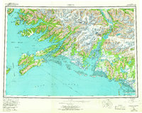
 2024 Cordova C-5 SE2024 Print · USGSCordova and its water-bound surroundings are captured here in the early twenty-first century as the town meets the Chugach National Forest. Researchers can trace local infrastructure around Eyak Lake and along the Copper River Highway to landmarks like Boy Scout Island.
End of results
Showing maps 1-9 of 9
Top cities near Eyak
Frequently asked questions
- What are the different types of historical maps available for Eyak?
- What is the oldest map of Eyak?
- Where can I purchase historical maps of Eyak for my home or office?
- Where can I download high-res historical maps of Eyak?
- Are there historical topographic maps available for Eyak?
- Is there historical aerial imagery available for Eyak?
- Where are historical maps of Eyak sourced from?