
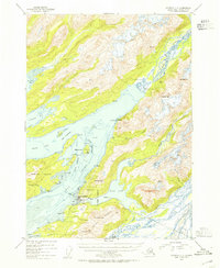
1953 Map of Cordova C-5
USGS Topo · Published 1954About this map
The coastal fishing hub of Cordova serves as the focal point of this 1953 survey, situated where the Heney Range meets the waters of Orca Inlet. This era captures the town's industrial footprint, showing the local Airstrip, a Cem, and a Cannery at Shepard Pt, alongside the Eyak Cannery further south near Mountain Slough. The geography is defined by a complex network of waterways, from the glacial runoff of the Rude River and Eyak River to the sheltered expanse of Eyak Lake.
Find a feature on this map
44 named features on this map. Tap any name to fly to it.
Don’t see what you’re looking for? This feature index may not catch every label — zoom into the map to look around manually.
Map Details
Editions of this 1953 Cordova C-5 Map
2 editions found
Other maps of this area

1948 · Cordova
USGS Topo · 1:250,000

1950 · Cordova C-6
USGS Topo · 1:63,360

1950 · Cordova C-4
USGS Topo · 1:63,360

1950 · Cordova D-5
USGS Topo · 1:63,360

1951 · Cordova
USGS Topo · 1:250,000

1951 · Cordova B-4
USGS Topo · 1:63,360

1951 · Cordova C-5
USGS Topo · 1:63,360

1951 · Cordova B-5
USGS Topo · 1:63,360

1951 · Cordova D-6
USGS Topo · 1:63,360

1951 · Cordova D-4
USGS Topo · 1:63,360