Old Maps of Deacons Landing, Alaska for Genealogy
Trace your family roots with 4 historic maps of Deacons Landing. These high-res maps reveal old neighborhoods, homesites, landmarks, and streets — helping you uncover where your ancestors lived and how the area evolved over time.
- Explore historic neighborhoods: Identify where your relatives may have lived in the 1800s or 1900s.
- Compare maps over time: Trace the changes in streets, buildings, and landmarks for multi-generational research.
- Perfect for genealogy & ancestry research: Used by family historians and researchers to map out lineage and migration.
These maps are an incredible resource for exploring your personal connection to Deacons Landing's past.
Deacons Landing, AK maps
(4)- 1951 Map of Iditarod, 1952 Print
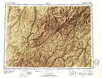 1951 Iditarod1952 Print · USGSThe Iditarod and Innoko river basins are captured here during the early fifties, showing the historic heart of the interior gold country. Researchers can trace seasonal travel routes and placer mining sites near Iditarod, Flat, and Dikeman.4 unique versions available
 - 1954 Map of Iditarod B-1, 1962 Print
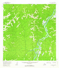 1954 Iditarod B-11962 Print · USGSThe Alaskan interior during the mid-fifties is documented here through its complex river networks and high survey points. Researchers can trace the path of the Kuskokwim River and locate a remote Cabin near the mouth of the Nunsatuk River.2 unique versions available
 - 1956 Map of Iditarod, 1965 Print
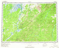 1956 Iditarod1965 Print · USGSInterior Alaska in the mid-fifties reveals a landscape of mining camps and military outposts. Trace the remnants of the gold rush at Iditarod, find placer mines near Flat, and see the early Takotna Air Force Station.3 unique versions available
 - 2019 Map of Iditarod B-1 NE, 2019 Print
 2019 Iditarod B-1 NE2019 Print · USGSThe interior of Alaska's Yukon-Koyukuk region is shown here in the early twenty-first century, centered on a massive bend in the river. Researchers can trace the path of the Kuskokwim River as it moves through township grids like T27N R37W and T28N R36W.
End of results
Showing maps 1-4 of 4
Frequently asked questions
- What are the different types of historical maps available for Deacons Landing?
- What is the oldest map of Deacons Landing?
- Where can I purchase historical maps of Deacons Landing for my home or office?
- Where can I download high-res historical maps of Deacons Landing?
- Are there historical topographic maps available for Deacons Landing?
- Is there historical aerial imagery available for Deacons Landing?
- Where are historical maps of Deacons Landing sourced from?