1900s (20th Century) Maps of Eagle, Alaska
Explore 3 historic maps of Eagle from the 1900s (20th Century). These maps offer a rare glimpse into what life looked like during the 1900s — showing old roads, neighborhoods, homes, and landmarks that have changed or disappeared over time.
Whether you're researching your family's past, planning a metal detecting trip, or studying how Eagle's landscape evolved across the 1900s, these high-resolution maps are a powerful tool for exploring the history of this region.
- Focus on a specific era: All maps on this page are from the 1900s, giving you a focused view of this time period.
- See what’s changed: Compare century-old streets, trails, and buildings to today's modern landscape using overlays and satellite layers.
- Research with precision: Use these maps for genealogy, historical research, land use analysis, or educational projects.
- View, download, or print: Maps are fully viewable online in high resolution, and can be downloaded or printed for your own records.
Start exploring Eagle's history through authentic maps from the 1900s. This is your window into the past.
Eagle, AK maps
(3)- 1951 Map of Eagle
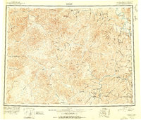 1951 Eagle1951 Print · USGSThe eastern Alaska wilderness at the Yukon border is captured here in the early fifties, a time when gold mining camps and bush outposts defined the interior. Trace the paths of prospectors through Chicken, Jack Wade, and the abandoned camp at Seventymile.4 unique versions available
 - 1956 Map of Eagle D-1, 1963 Print
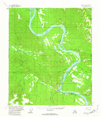 1956 Eagle D-11963 Print · USGSThe Upper Yukon region at the edge of the Alaska-Yukon border reveals a landscape of river-based settlements and emerging roads in the mid-1950s. Historians can trace the layouts of Eagle and Eagle Village or locate remote cabins along the Seventymile River.3 unique versions available
 - 1957 Map of Eagle, 1966 Print
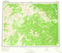 1957 Eagle1966 Print · USGSThe eastern Alaska interior comes into focus during the mid-fifties, showing the remote river outposts and mining camps along the Canadian border. Genealogists and historians can trace the early Taylor Highway corridor to Chicken, Jack Wade, and Eagle Village.6 unique versions available
End of results
Showing maps 1-3 of 3
Frequently asked questions
- What are the different types of historical maps available for Eagle?
- What is the oldest map of Eagle?
- Where can I purchase historical maps of Eagle for my home or office?
- Where can I download high-res historical maps of Eagle?
- Are there historical topographic maps available for Eagle?
- Is there historical aerial imagery available for Eagle?
- Where are historical maps of Eagle sourced from?