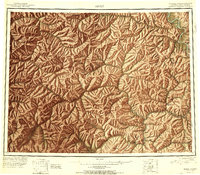
1951 Map of Eagle
USGS Topo · Published 1951About this map
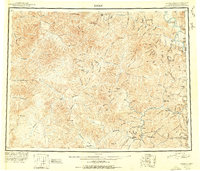
The Eagle riverfront and the rugged interior of the Fourth Judicial Division define this 1951 reconnaissance survey of the eastern Alaska wilderness. This era was marked by the transition from old mining outposts to more modern connectivity, anchored by the Fortymile Highway and small bush strips like the Gold Creek Airstrip. Remote settlements and shelter cabins suggest a landscape still heavily reliant on seasonal gold mining and trapping. Several locations, including Seventymile, Joseph, and Kechumstuk, are already noted as abandoned, marking the decline of early 20th-century gold camps. The map traces the intricate drainages of the Charley River and Mosquito Fork, providing a detailed look at a geography where named features like Glacier Mountain and The Kink served as vital landmarks for travel between the Yukon border and the interior.
Find a feature on this map
145 named features on this map. Tap any name to fly to it.
Don’t see what you’re looking for? This feature index may not catch every label — zoom into the map to look around manually.
Map Details
Editions of this 1951 Eagle Map
4 editions found