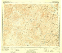
1951 Map of Eagle
USGS Topo · Published 1956About this map
The Alaska Yukon boundary defines the eastern edge of this expansive mid-century survey, where the Taylor Highway provides a lifeline to remote settlements. Along the Seventymile River and the winding Charley River, the landscape is dotted with outposts of early Alaskan industry and transport, from the Landing Field at Eagle to the Bonanza Bar mining area.
Find a feature on this map
136 named features on this map. Tap any name to fly to it.
Don’t see what you’re looking for? This feature index may not catch every label — zoom into the map to look around manually.
Map Details
Editions of this 1951 Eagle Map
4 editions found
Other maps of this area

1899 · Fortymile
USGS Topo · 1:250,000

1949 · Tanacross
USGS Topo · 1:250,000

1950 · Tanacross
USGS Topo · 1:250,000

1950 · Mount Hayes
USGS Topo · 1:250,000

1950 · Big Delta
USGS Topo · 1:250,000

1951 · Big Delta
USGS Topo · 1:250,000

1951 · Mount Hayes
USGS Topo · 1:250,000

1951 · Charley River
USGS Topo · 1:250,000

1951 · Eagle
USGS Topo · 1:250,000

1951 · Circle
USGS Topo · 1:250,000