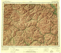
1951 Map of Eagle
USGS Topo · Published 1956About this map
Eagle stands as the primary gateway to this subarctic landscape, situated near the Alaska Yukon boundary along the upper reaches of the Seventymile River. In the early 1950s, the region was defined by a mix of active mining communities and fading frontier settlements, with several sites already labeled as abandoned. The map documents the vital role of aviation in this road-sparse interior, featuring remote landing strips such as Gold Creek Airstrip and Lassen Airstrip.
Find a feature on this map
115 named features on this map. Tap any name to fly to it.
Don’t see what you’re looking for? This feature index may not catch every label — zoom into the map to look around manually.
Map Details
Editions of this 1951 Eagle Map
4 editions found
Other maps of this area

1899 · Fortymile
USGS Topo · 1:250,000

1949 · Tanacross
USGS Topo · 1:250,000

1950 · Tanacross
USGS Topo · 1:250,000

1950 · Mount Hayes
USGS Topo · 1:250,000

1950 · Big Delta
USGS Topo · 1:250,000

1951 · Big Delta
USGS Topo · 1:250,000

1951 · Mount Hayes
USGS Topo · 1:250,000

1951 · Charley River
USGS Topo · 1:250,000

1951 · Eagle
USGS Topo · 1:250,000

1951 · Circle
USGS Topo · 1:250,000