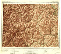
1951 Map of Eagle
USGS Topo · Published 1951About this map
Mining and remote settlement define the northern reaches of the Fourth Judicial Division as the mid-century era begins. The Taylor Highway snakes through the high terrain, connecting the gold-country outpost of Chicken and Jack Wade to the international border at Boundary. Near the banks of the Yukon River, the town of Eagle sits across from Seventymile Bluff, while upstream, several earlier sites are noted as out of use, including Seventymile and Joseph. The landscape is a network of drainage systems, including the Charley River and Seventymile River, which once supported intense prospecting. Notable landmarks for travel and survival include the Gravel Gulch Shelter Cabin and the curious river feature known simply as The Kink. This 1951 survey, compiled from trimetrogon photography, marks the transition from old pack trails to more established motor routes in the Alaskan interior.
Find a feature on this map
138 named features on this map. Tap any name to fly to it.
Don’t see what you’re looking for? This feature index may not catch every label — zoom into the map to look around manually.
Map Details
Editions of this 1951 Eagle Map
4 editions found
Other maps of this area

1899 · Fortymile
USGS Topo · 1:250,000

1949 · Tanacross
USGS Topo · 1:250,000

1950 · Tanacross
USGS Topo · 1:250,000

1950 · Mount Hayes
USGS Topo · 1:250,000

1950 · Big Delta
USGS Topo · 1:250,000

1951 · Big Delta
USGS Topo · 1:250,000

1951 · Mount Hayes
USGS Topo · 1:250,000

1951 · Charley River
USGS Topo · 1:250,000

1951 · Eagle
USGS Topo · 1:250,000

1951 · Circle
USGS Topo · 1:250,000