Old Maps of Elfin Cove, Alaska for Genealogy
Trace your family roots with 5 historic maps of Elfin Cove. These high-res maps reveal old neighborhoods, homesites, landmarks, and streets — helping you uncover where your ancestors lived and how the area evolved over time.
- Explore historic neighborhoods: Identify where your relatives may have lived in the 1800s or 1900s.
- Compare maps over time: Trace the changes in streets, buildings, and landmarks for multi-generational research.
- Perfect for genealogy & ancestry research: Used by family historians and researchers to map out lineage and migration.
These maps are an incredible resource for exploring your personal connection to Elfin Cove's past.
Elfin Cove, AK maps
(5)- 1948 Map of Mount Fairweather A-2, 1957 Print
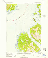 1948 Mount Fairweather A-21957 Print · USGSSoutheast Alaska's maritime wilderness is captured here in the late 1940s, showing the isolated fishing and mining outposts of the northern Alexander Archipelago. Researchers can trace the coastal layout of Elfin Cove and Chichagof, or locate landmarks like Bingham Peak and Lisianski Strait.3 unique versions available
 - 1951 Map of Mt Fairweather, 1953 Print
 1951 Mt Fairweather1953 Print · USGSCoastal Alaska at the mid-century remains a landscape of massive ice and isolated outposts. Researchers can trace the remote Solomon Railroad and early settlements like Pelican and Elfin Cove nestled along the glacial waterways.2 unique versions available
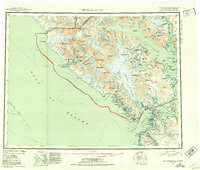
 - 1961 Map of Mt Fairweather, 1966 Print
 1961 Mt Fairweather1966 Print · USGSSoutheast Alaska’s coastal wilderness is documented here during the mid-twentieth century, showcasing the expansive ice fields of Glacier Bay National Monument. Researchers can trace the complex shorelines of Lituya Bay, locate remote peaks like Mt Crillon, and study the island passages of Cross Sound.4 unique versions available
 - 2017 Map of Mount Fairweather A-2 NE, 2017 Print
 2017 Mount Fairweather A-2 NE2017 Print · USGSCovers Elfin Cove, including Unorganized Borough, United States, and other nearby areas
 - 2021 Map of Mount Fairweather A-2 NE, 2021 Print
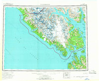
 2021 Mount Fairweather A-2 NE2021 Print · USGSCoastal life in the Hoonah-Angoon Census Area is centered on the water and the small settlement of Elfin Cove in this modern survey. Researchers can trace maritime landmarks across the Inian Islands and locate remote spots like The Hobbit Hole or Granite Cove.
End of results
Showing maps 1-5 of 5
Frequently asked questions
- What are the different types of historical maps available for Elfin Cove?
- What is the oldest map of Elfin Cove?
- Where can I purchase historical maps of Elfin Cove for my home or office?
- Where can I download high-res historical maps of Elfin Cove?
- Are there historical topographic maps available for Elfin Cove?
- Is there historical aerial imagery available for Elfin Cove?
- Where are historical maps of Elfin Cove sourced from?