Old Maps of Elilakok, Alaska for Hiking & Exploration
Hike through history with 4 historic maps of Elilakok. Explore old trails, ghost towns, and forgotten backroads — perfect for outdoor adventurers and local explorers.
- Rediscover forgotten places: Map out old mining camps, roads, and footpaths that no longer exist on modern maps.
- Layer with modern tools: Combine with LiDAR or satellite views to plan hikes through historical terrain.
- Made for exploration: Popular among hikers, overlanders, and local history lovers.
Use these maps to find adventure and explore the hidden past of Elilakok.
Elilakok, AK maps
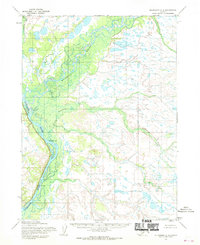
(4)- 1951 Map of Dillingham, 1952 Print
 1951 Dillingham1952 Print · USGSDillingham and the Bristol Bay river systems are captured here in the early fifties, showing a remote landscape linked by water and seasonal camps. Researchers can trace early settlements and post offices at New Stuyahok, Ekwok, and Kvichak.
 - 1954 Map of Dillingham, 1967 Print
 1954 Dillingham1967 Print · USGSBristol Bay's interior river systems are mapped here in the mid-1950s, showing a landscape defined by water and winter travel. Researchers can trace remote settlements like Koliganek and Levelock or find family landmarks along the Nushagak River and Lake Aleknagik.3 unique versions available
 - 1954 Map of Dillingham C-3, 1968 Print
 1954 Dillingham C-31968 Print · USGSThe Nushagak and Mulchatna rivers dominate this mid-century Alaskan interior survey, capturing the region just before statehood. Genealogists and researchers can trace the locations of seasonal Cabins and the settlement at Nunachuak along the braided riverbanks.2 unique versions available
 - 2019 Map of Dillingham C-3 SW, 2019 Print
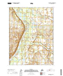 2019 Dillingham C-3 SW2019 Print · USGSThe Nushagak River basin in 2019 reveals a landscape of complex waterways and seasonal wetlands in southwest Alaska. Researchers and geographers can trace the course of the Nushagak River and the settlement at Nunachuak near the mouth of Nunachuak Cr.
End of results
Showing maps 1-4 of 4
Top cities near Elilakok
Frequently asked questions
- What are the different types of historical maps available for Elilakok?
- What is the oldest map of Elilakok?
- Where can I purchase historical maps of Elilakok for my home or office?
- Where can I download high-res historical maps of Elilakok?
- Are there historical topographic maps available for Elilakok?
- Is there historical aerial imagery available for Elilakok?
- Where are historical maps of Elilakok sourced from?