1900s (20th Century) Maps of Galena, Alaska
Explore 8 historic maps of Galena from the 1900s (20th Century). These maps offer a rare glimpse into what life looked like during the 1900s — showing old roads, neighborhoods, homes, and landmarks that have changed or disappeared over time.
Whether you're researching your family's past, planning a metal detecting trip, or studying how Galena's landscape evolved across the 1900s, these high-resolution maps are a powerful tool for exploring the history of this region.
- Focus on a specific era: All maps on this page are from the 1900s, giving you a focused view of this time period.
- See what’s changed: Compare century-old streets, trails, and buildings to today's modern landscape using overlays and satellite layers.
- Research with precision: Use these maps for genealogy, historical research, land use analysis, or educational projects.
- View, download, or print: Maps are fully viewable online in high resolution, and can be downloaded or printed for your own records.
Start exploring Galena's history through authentic maps from the 1900s. This is your window into the past.
Galena, AK maps
(8)- 1945 Map of Nulato, 1954 Print
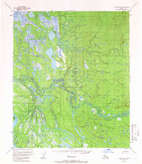
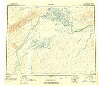 1945 Nulato1954 Print · USGSThe Yukon and Koyukuk rivers serve as the lifeblood of this Alaskan interior region during the mid-forties. Researchers can trace the traditional Kaltag Portage and locate established riverside settlements like Nulato, Galena, and the village at Koyukuk.2 unique versions available
 - 1951 Map of Nulato
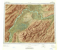
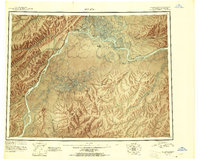 1951 Nulato1951 Print · USGSThe Yukon and Koyukuk Rivers meet in this mid-century Alaska survey, showing the vital river outposts and sloughs of the interior. Researchers can trace remote river life through landing areas at Galena, riverbank Cabins, and landmarks like Bishop Rock and Traders Island.2 unique versions available
 - 1952 Map of Nulato C-2, 1957 Print
 1952 Nulato C-21957 Print · USGSThe Yukon River interior comes into focus in the early fifties, centering on the strategic development of Galena Air Force Base. Researchers can trace the military footprint alongside the river and locate the site of Louden (Aban'd) and its Cem.
 - 1952 Map of Nulato D-2, 1957 Print
 1952 Nulato D-21957 Print · USGSThe Yukon River corridor and its braided channels are captured here in the early fifties during the expansion of interior Alaskan military outposts. Researchers can trace the boundaries of Galena Air Force Base and explore the river's geography through Serpentine Island and Bear Creek.
 - 1952 Map of Nulato, 1958 Print
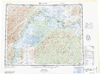
 1952 Nulato1958 Print · USGSThe Yukon River interior comes into focus during the early fifties, documenting a region of river settlements and rising military aviation. Researchers can trace the Abandoned Telegraph Line, locate the Louden Cem, or study the footprint of the Galena Air Force Base.4 unique versions available
 - 1953 Map of Nulato C-2, 1963 Print
 1953 Nulato C-21963 Print · USGSThe Yukon River dominates this mid-century Alaskan interior as the Cold War era brought new strategic importance to remote outposts. Trace the layout of Galena Air Force Base Auxiliary Field and the abandoned settlement at Louden (Aband).3 unique versions available
 - 1954 Map of Nulato D-2, 1965 Print
 1954 Nulato D-21965 Print · USGSThe Yukon-Koyukuk wilderness in the mid-1950s is defined here by the intersection of military aviation and a complex river system. Map collectors and researchers can trace the footprint of Galena Air Force Base and the braided channels surrounding Serpentine Island and Lark Island.3 unique versions available
 - 1964 Map of Nulato
 1964 Nulato1964 Print · USGSThe Yukon interior in the early sixties reveals a landscape shaped by river travel and Cold War aviation. Researchers can trace the ABANDONED TELEGRAPH LINE across the northern wilderness or locate historical sites like Nulato, Louden, and the Galena Air Force Base.
End of results
Showing maps 1-8 of 8
Frequently asked questions
- What are the different types of historical maps available for Galena?
- What is the oldest map of Galena?
- Where can I purchase historical maps of Galena for my home or office?
- Where can I download high-res historical maps of Galena?
- Are there historical topographic maps available for Galena?
- Is there historical aerial imagery available for Galena?
- Where are historical maps of Galena sourced from?