1900s (20th Century) Maps of Gambell, Alaska
Explore 3 historic maps of Gambell from the 1900s (20th Century). These maps offer a rare glimpse into what life looked like during the 1900s — showing old roads, neighborhoods, homes, and landmarks that have changed or disappeared over time.
Whether you're researching your family's past, planning a metal detecting trip, or studying how Gambell's landscape evolved across the 1900s, these high-resolution maps are a powerful tool for exploring the history of this region.
- Focus on a specific era: All maps on this page are from the 1900s, giving you a focused view of this time period.
- See what’s changed: Compare century-old streets, trails, and buildings to today's modern landscape using overlays and satellite layers.
- Research with precision: Use these maps for genealogy, historical research, land use analysis, or educational projects.
- View, download, or print: Maps are fully viewable online in high resolution, and can be downloaded or printed for your own records.
Start exploring Gambell's history through authentic maps from the 1900s. This is your window into the past.
Gambell, AK maps
(3)- 1948 Map of St Lawrence, 1954 Print
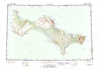 1948 St Lawrence1954 Print · USGSSaint Lawrence Island in the late 1940s is shown as a land of seasonal movement and subsistence living. Researchers can trace historic sites like the Kukuliak (Old Village Site), locate Ataaka's Camp, and follow the established Winter Trail across the island.7 unique versions available
 - 1949 Map of St Lawrence
 1949 St Lawrence1949 Print · USGSSt. Lawrence Island in the Bering Sea is shown here as it transitioned into the mid-twentieth century, dominated by subsistence camps and traditional trails. Researchers can trace seasonal sites like Ataaka's Camp, the Reindeer Camp and Corral, and the Kukuliak (Old Village Site).2 unique versions available
 - 1964 Map of St Lawrence
 1964 St Lawrence1964 Print · USGSSt. Lawrence Island appears in the mid-sixties as a landscape of subsistence camps and ancient village sites in the Bering Sea. Researchers can locate traditional outposts like Siknik Trapping Camp, the Kookoolik (Old Village Site), and Reindeer Camp.
End of results
Showing maps 1-3 of 3
Frequently asked questions
- What are the different types of historical maps available for Gambell?
- What is the oldest map of Gambell?
- Where can I purchase historical maps of Gambell for my home or office?
- Where can I download high-res historical maps of Gambell?
- Are there historical topographic maps available for Gambell?
- Is there historical aerial imagery available for Gambell?
- Where are historical maps of Gambell sourced from?