Old Maps of Gambell, Alaska for Hiking & Exploration
Hike through history with 7 historic maps of Gambell. Explore old trails, ghost towns, and forgotten backroads — perfect for outdoor adventurers and local explorers.
- Rediscover forgotten places: Map out old mining camps, roads, and footpaths that no longer exist on modern maps.
- Layer with modern tools: Combine with LiDAR or satellite views to plan hikes through historical terrain.
- Made for exploration: Popular among hikers, overlanders, and local history lovers.
Use these maps to find adventure and explore the hidden past of Gambell.
Gambell, AK maps
(7)- 1948 Map of St Lawrence, 1954 Print
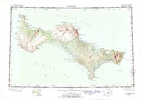 1948 St Lawrence1954 Print · USGSSaint Lawrence Island in the late 1940s is shown as a land of seasonal movement and subsistence living. Researchers can trace historic sites like the Kukuliak (Old Village Site), locate Ataaka's Camp, and follow the established Winter Trail across the island.7 unique versions available
 - 1949 Map of St Lawrence
 1949 St Lawrence1949 Print · USGSSt. Lawrence Island in the Bering Sea is shown here as it transitioned into the mid-twentieth century, dominated by subsistence camps and traditional trails. Researchers can trace seasonal sites like Ataaka's Camp, the Reindeer Camp and Corral, and the Kukuliak (Old Village Site).2 unique versions available
 - 1964 Map of St Lawrence
 1964 St Lawrence1964 Print · USGSSt. Lawrence Island appears in the mid-sixties as a landscape of subsistence camps and ancient village sites in the Bering Sea. Researchers can locate traditional outposts like Siknik Trapping Camp, the Kookoolik (Old Village Site), and Reindeer Camp.
 - 2020 Map of Saint Lawrence D-6 SW, 2020 Print
 2020 Saint Lawrence D-6 SW2020 Print · USGSSaint Lawrence Island's southwestern coast is documented in this recent survey, showing the relationship between the island and the surrounding sea. Trace the series of coastal landmarks including Kavalghak Bay, Singik Point, and Upapak Point.
 - 2020 Map of Saint Lawrence D-6 NE, 2020 Print
 2020 Saint Lawrence D-6 NE2020 Print · USGSGambell stands at the edge of the Bering Sea in this modern survey of St. Lawrence Island's northwestern tip. Researchers can trace the layout of the village and Gambell Airport alongside the steep slopes of Sevuokuk Mtn and Sevooghak Mtn.
 - 2020 Map of Saint Lawrence D-6 SE, 2020 Print
 2020 Saint Lawrence D-6 SE2020 Print · USGSSaint Lawrence Island's northern coastline is captured here in the early twenty-first century, showing the intersection of the Bering Sea and this remote landmass. Researchers can trace landforms and coastal elevations from the expanse of Nirgeehak Beach to Niyghakpak Cliff and Dovelawik Bay.
 - 2020 Map of Saint Lawrence D-6 NW, 2020 Print
 2020 Saint Lawrence D-6 NW2020 Print · USGSSaint Lawrence Island and the Bering Sea are the focus of this 2020 survey in the Nome Census Area. Researchers can trace the coastal boundary and the administrative grid of T20S R67W along the island's northwestern edge.
End of results
Showing maps 1-7 of 7
Frequently asked questions
- What are the different types of historical maps available for Gambell?
- What is the oldest map of Gambell?
- Where can I purchase historical maps of Gambell for my home or office?
- Where can I download high-res historical maps of Gambell?
- Are there historical topographic maps available for Gambell?
- Is there historical aerial imagery available for Gambell?
- Where are historical maps of Gambell sourced from?