Old Maps of Haycock, Alaska for Hiking & Exploration
Hike through history with 5 historic maps of Haycock. Explore old trails, ghost towns, and forgotten backroads — perfect for outdoor adventurers and local explorers.
- Rediscover forgotten places: Map out old mining camps, roads, and footpaths that no longer exist on modern maps.
- Layer with modern tools: Combine with LiDAR or satellite views to plan hikes through historical terrain.
- Made for exploration: Popular among hikers, overlanders, and local history lovers.
Use these maps to find adventure and explore the hidden past of Haycock.
Haycock, AK maps
(5)- 1950 Map of Candle A-5, 1956 Print
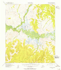 1950 Candle A-51956 Print · USGSThe Seward Peninsula in the mid-twentieth century remained a territory of remote mining outposts and river navigation. Researchers can trace the industrial footprint of the Gold Mine at Haycock and the vital logistical links at Dime Landing and the local Landing Strip.3 unique versions available
 - 1951 Map of Candle
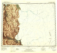 1951 Candle1951 Print · USGSThe gold-producing drainages of the Seward Peninsula are shown here in the early 1950s, a landscape defined by hydraulic mining and aviation. Genealogists and historians can trace remote outposts like Snyder Roadhouse, the mining hub of Candle, and the Candle Ditch.3 unique versions available
 - 1955 Map of Candle, 1961 Print
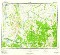 1955 Candle1961 Print · USGSNorthwest Alaska in the mid-fifties reveals a landscape of remote settlements and aviation outposts connected by river systems. Researchers can trace the early infrastructure of Candle, the Reindeer Corral near Buckland, and old mining works along Gold Run.6 unique versions available
 - 1964 Map of Candle
 1964 Candle1964 Print · USGSRemote outposts and gold-bearing creeks mark the Northwest Arctic during the mid-1960s, a time of transition for the Seward Peninsula. You can trace early overland travel along the Tractor Trail or locate vanished mining sites at Haycock and Dime Landing.
 - 2014 Map of Candle A-5 NE, 2014 Print
 2014 Candle A-5 NE2014 Print · USGSRemote Nome interior lands come into focus during the early twenty-first century as the landscape around Haycock is meticulously surveyed. Trace the routes of Koyuk Hotsprings Road and explore drainages like Dime Cr and Dollar Cr.
End of results
Showing maps 1-5 of 5
Frequently asked questions
- What are the different types of historical maps available for Haycock?
- What is the oldest map of Haycock?
- Where can I purchase historical maps of Haycock for my home or office?
- Where can I download high-res historical maps of Haycock?
- Are there historical topographic maps available for Haycock?
- Is there historical aerial imagery available for Haycock?
- Where are historical maps of Haycock sourced from?