Old Maps of Hogatza, Alaska for Genealogy
Trace your family roots with 6 historic maps of Hogatza. These high-res maps reveal old neighborhoods, homesites, landmarks, and streets — helping you uncover where your ancestors lived and how the area evolved over time.
- Explore historic neighborhoods: Identify where your relatives may have lived in the 1800s or 1900s.
- Compare maps over time: Trace the changes in streets, buildings, and landmarks for multi-generational research.
- Perfect for genealogy & ancestry research: Used by family historians and researchers to map out lineage and migration.
These maps are an incredible resource for exploring your personal connection to Hogatza's past.
Hogatza, AK maps
(6)- 1951 Map of Hughes, 1952 Print
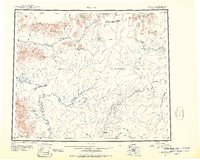 1951 Hughes1952 Print · USGSThe interior of Alaska during the early fifties reveals a landscape of seasonal routes and river-based settlements. Researchers can trace the path of the Arctic Circle past isolated cabins and remote outposts like the Hughes Landing Area and Hog River Landing Area.
 - 1956 Map of Hughes, 1958 Print
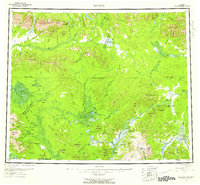 1956 Hughes1958 Print · USGSJust north of the Arctic Circle in the mid-fifties, this interior Alaskan landscape centers on the river life of the Koyukuk River. Genealogists and historians can trace the community at Hughes and remote outposts like Discovery or the Elevenmile Landing Area.6 unique versions available
 - 1964 Map of Hughes
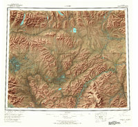
 1964 Hughes1964 Print · USGSThe Arctic Circle crosses this interior Alaskan wilderness in the mid-1960s, a period when the river was the primary lifeline. Genealogists and researchers can trace remote settlements and routes like Hughes, the Potziligi Portage, and several scattered Cabins.
 - 1965 Map of Hughes, 1966 Print
 1965 Hughes1966 Print · USGSThe Alaskan interior during the mid-1960s reveals a wilderness organized by river travel and remote outposts. Researchers can trace historic transit corridors like the Sled Trail and Potzitigi Portage, or locate the Cem and airstrips at Hughes.
 - 1986 Map of Hughes A-6
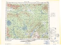
 1986 Hughes A-61986 Print · USGSThe Alaskan interior near the Zane Hills is shown here in the mid-eighties as a landscape of remote mining and wilderness conservation. Researchers can trace the industrial footprint at Hogatza with its Landing Strip and Tailings, or locate the settlement of Hogatzakhotak.
 - 2016 Map of Hughes A-6 NE, 2016 Print
 2016 Hughes A-6 NE2016 Print · USGSThe Yukon-Koyukuk interior comes into focus during the mid-2010s, showing a landscape defined by its remote river systems and isolated outposts. Researchers can trace the drainage of Wallick Cr or locate the vital Hog River Airport near the settlement of Hogatzat.
End of results
Showing maps 1-6 of 6
Frequently asked questions
- What are the different types of historical maps available for Hogatza?
- What is the oldest map of Hogatza?
- Where can I purchase historical maps of Hogatza for my home or office?
- Where can I download high-res historical maps of Hogatza?
- Are there historical topographic maps available for Hogatza?
- Is there historical aerial imagery available for Hogatza?
- Where are historical maps of Hogatza sourced from?