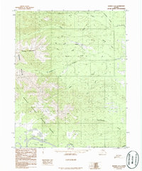
1986 Map of Hughes A-6
USGS Topo · Published 1986About this map
Koyukuk River and its wide floodplains dominate the southern portion of this landscape, winding past Treat Island within the Koyukuk National Wildlife Refuge. The map captures a transition from the broad river valley into the rising elevations of the Zane Hills and Caribou Mountain to the north. Evidence of industrial activity is centered near Hogatza, where a Landing Strip and significant Tailings piles suggest remote mining operations along the interior waterways. Numerous drainage systems, such as Clear Creek and Moraine Creek, carve through the terrain, while the settlement at Hogatzakhotak sits near the junction of mountain runoff and the lower wetlands. This 1986 edition is based on early 1970s photography, preserving the layout of these isolated outposts and their relationship to the shifting river channels of the Alaskan interior.
Find a feature on this map
21 named features on this map. Tap any name to fly to it.
Don’t see what you’re looking for? This feature index may not catch every label — zoom into the map to look around manually.
Map Details
Editions of this 1986 Hughes A-6 Map
This is the sole edition of this map. No revisions or reprints were ever made.
Other maps of this area

1951 · Shungnak
USGS Topo · 1:250,000

1951 · Kateel River
USGS Topo · 1:250,000

1951 · Hughes
USGS Topo · 1:250,000

1951 · Melozitna
USGS Topo · 1:250,000

1954 · Melozitna D-5
USGS Topo · 1:63,360

1954 · Kateel River D-1
USGS Topo · 1:63,360

1954 · Melozitna D-6
USGS Topo · 1:63,360

1955 · Shungnak
USGS Topo · 1:250,000

1955 · Kateel River
USGS Topo · 1:250,000

1956 · Hughes
USGS Topo · 1:250,000