Old Maps of Hoonah, Alaska for Academic Research
Study the evolution of Hoonah with 8 high-resolution historic maps. Whether you're teaching, researching, or modeling changes in land use, these maps provide essential visual documentation of urban, environmental, and geographic change.
- Analyze long-term change: Track patterns in development, transportation, and natural features.
- Ideal for environmental or urban studies: Support academic projects with primary historical map data.
- Use in the classroom or lab: Educators and researchers rely on these maps to bring historical context to life.
These maps are a powerful tool for teaching, research, and visualizing how Hoonah has changed over the decades.
Hoonah, AK maps
(8)- 1951 Map of Juneau
 1951 Juneau1951 Print · USGSJuneau and the industrial waterfront of the Gastineau Channel are shown here at the start of the 1950s. Researchers can trace the mid-century footprint of Juneau, the mining history of Treadwell, and remote maritime outposts like Hoonah and Gustavus.4 unique versions available
 - 1951 Map of Juneau A-5, 1952 Print
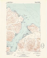 1951 Juneau A-51952 Print · USGSThe Tlingit village of Hoonah and its surrounding coastal waters are captured here in the early fifties. Local historians can trace maritime life around Hoonah Harbor, from the waterfront Cannery to the inland Spasski Trail and old Cem sites.6 unique versions available
 - 1962 Map of Juneau, 1966 Print
 1962 Juneau1966 Print · USGSSoutheast Alaska in the early sixties showcases a maritime landscape defined by the Tongass National Forest and the peaks of the Coast Mountains. Trace the footprints of coastal industry at Treadwell, Thane, and the regional hub of Juneau.7 unique versions available
 - 1994 Map of Juneau A-5, 1998 Print
 1994 Juneau A-51998 Print · USGSCoastal Chichagof Island comes into focus in the 1990s, centering on the maritime hub of Hoonah and the surrounding wilderness. Researchers can trace the development of local infrastructure from the White Alice Comm Site to the Whitestone Logging Camp and Hoonah Harbor.
 - 2015 Map of Juneau A-5 NE, 2015 Print
 2015 Juneau A-5 NE2015 Print · USGSCovers Hoonah, including Unorganized Borough, Haines, and other nearby areas
 - 2017 Map of Juneau A-5 SE, 2017 Print
 2017 Juneau A-5 SE2017 Print · USGSCovers Hoonah, including Whitestone Logging Camp (Abandoned), Whitestone Logging Camp, and other nearby areas
 - 2021 Map of Juneau A-5 NE, 2021 Print
 2021 Juneau A-5 NE2021 Print · USGSThe northern shore of Chichagof Island meets the sea in the early twenty-first century. Genealogists and maritime historians can locate Icy Strait Point Cem and trace the coastal geography of Cannery Point and Point Sophia.
 - 2021 Map of Juneau A-5 SE, 2021 Print
 2021 Juneau A-5 SE2021 Print · USGSThe Tlingit community of Hoonah and its surrounding coastal waters are documented here in the early twenty-first century. Researchers can trace local landmarks from the Hoonah Courthouse to industrial sites like the Whitestone Logging Camp.
End of results
Showing maps 1-8 of 8
Frequently asked questions
- What are the different types of historical maps available for Hoonah?
- What is the oldest map of Hoonah?
- Where can I purchase historical maps of Hoonah for my home or office?
- Where can I download high-res historical maps of Hoonah?
- Are there historical topographic maps available for Hoonah?
- Is there historical aerial imagery available for Hoonah?
- Where are historical maps of Hoonah sourced from?