1900s (20th Century) Maps of Hughes, Alaska
Explore 6 historic maps of Hughes from the 1900s (20th Century). These maps offer a rare glimpse into what life looked like during the 1900s — showing old roads, neighborhoods, homes, and landmarks that have changed or disappeared over time.
Whether you're researching your family's past, planning a metal detecting trip, or studying how Hughes's landscape evolved across the 1900s, these high-resolution maps are a powerful tool for exploring the history of this region.
- Focus on a specific era: All maps on this page are from the 1900s, giving you a focused view of this time period.
- See what’s changed: Compare century-old streets, trails, and buildings to today's modern landscape using overlays and satellite layers.
- Research with precision: Use these maps for genealogy, historical research, land use analysis, or educational projects.
- View, download, or print: Maps are fully viewable online in high resolution, and can be downloaded or printed for your own records.
Start exploring Hughes's history through authentic maps from the 1900s. This is your window into the past.
Hughes, AK maps
(6)- 1951 Map of Hughes, 1952 Print
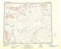 1951 Hughes1952 Print · USGSThe interior of Alaska during the early fifties reveals a landscape of seasonal routes and river-based settlements. Researchers can trace the path of the Arctic Circle past isolated cabins and remote outposts like the Hughes Landing Area and Hog River Landing Area.
 - 1955 Map of Hughes A-3, 1958 Print
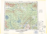
 1955 Hughes A-31958 Print · USGSThe Koyukuk River valley in the mid-1950s was a remote interior landscape reliant on seasonal transport and river access. You can trace the Sled Trail as it passes through Hatdolitna Canyon or locate the Landing Strip at the settlement of Hughes.
 - 1956 Map of Hughes, 1958 Print
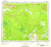 1956 Hughes1958 Print · USGSJust north of the Arctic Circle in the mid-fifties, this interior Alaskan landscape centers on the river life of the Koyukuk River. Genealogists and historians can trace the community at Hughes and remote outposts like Discovery or the Elevenmile Landing Area.6 unique versions available
 - 1956 Map of Hughes A-3, 1974 Print
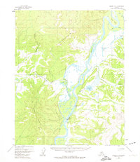 1956 Hughes A-31974 Print · USGSThe Koyukuk River valley in the mid-fifties centered on the small riverbank settlement of Hughes. Local history and genealogy researchers can trace the early layout of the village, its riverfront Gaging Sta, the local Cem, and traditional Sled Trails.3 unique versions available
 - 1964 Map of Hughes
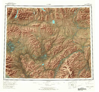
 1964 Hughes1964 Print · USGSThe Arctic Circle crosses this interior Alaskan wilderness in the mid-1960s, a period when the river was the primary lifeline. Genealogists and researchers can trace remote settlements and routes like Hughes, the Potziligi Portage, and several scattered Cabins.
 - 1965 Map of Hughes, 1966 Print
 1965 Hughes1966 Print · USGSThe Alaskan interior during the mid-1960s reveals a wilderness organized by river travel and remote outposts. Researchers can trace historic transit corridors like the Sled Trail and Potzitigi Portage, or locate the Cem and airstrips at Hughes.
End of results
Showing maps 1-6 of 6
Frequently asked questions
- What are the different types of historical maps available for Hughes?
- What is the oldest map of Hughes?
- Where can I purchase historical maps of Hughes for my home or office?
- Where can I download high-res historical maps of Hughes?
- Are there historical topographic maps available for Hughes?
- Is there historical aerial imagery available for Hughes?
- Where are historical maps of Hughes sourced from?