Old Maps of Hughes, Alaska for Hiking & Exploration
Hike through history with 8 historic maps of Hughes. Explore old trails, ghost towns, and forgotten backroads — perfect for outdoor adventurers and local explorers.
- Rediscover forgotten places: Map out old mining camps, roads, and footpaths that no longer exist on modern maps.
- Layer with modern tools: Combine with LiDAR or satellite views to plan hikes through historical terrain.
- Made for exploration: Popular among hikers, overlanders, and local history lovers.
Use these maps to find adventure and explore the hidden past of Hughes.
Hughes, AK maps
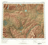
(8)- 1951 Map of Hughes, 1952 Print
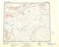 1951 Hughes1952 Print · USGSThe interior of Alaska during the early fifties reveals a landscape of seasonal routes and river-based settlements. Researchers can trace the path of the Arctic Circle past isolated cabins and remote outposts like the Hughes Landing Area and Hog River Landing Area.
 - 1955 Map of Hughes A-3, 1958 Print
 1955 Hughes A-31958 Print · USGSThe Koyukuk River valley in the mid-1950s was a remote interior landscape reliant on seasonal transport and river access. You can trace the Sled Trail as it passes through Hatdolitna Canyon or locate the Landing Strip at the settlement of Hughes.
 - 1956 Map of Hughes, 1958 Print
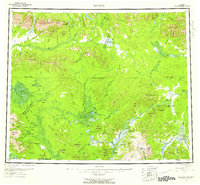 1956 Hughes1958 Print · USGSJust north of the Arctic Circle in the mid-fifties, this interior Alaskan landscape centers on the river life of the Koyukuk River. Genealogists and historians can trace the community at Hughes and remote outposts like Discovery or the Elevenmile Landing Area.6 unique versions available
 - 1956 Map of Hughes A-3, 1974 Print
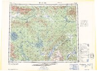
 1956 Hughes A-31974 Print · USGSThe Koyukuk River valley in the mid-fifties centered on the small riverbank settlement of Hughes. Local history and genealogy researchers can trace the early layout of the village, its riverfront Gaging Sta, the local Cem, and traditional Sled Trails.3 unique versions available
 - 1964 Map of Hughes
 1964 Hughes1964 Print · USGSThe Arctic Circle crosses this interior Alaskan wilderness in the mid-1960s, a period when the river was the primary lifeline. Genealogists and researchers can trace remote settlements and routes like Hughes, the Potziligi Portage, and several scattered Cabins.
 - 1965 Map of Hughes, 1966 Print
 1965 Hughes1966 Print · USGSThe Alaskan interior during the mid-1960s reveals a wilderness organized by river travel and remote outposts. Researchers can trace historic transit corridors like the Sled Trail and Potzitigi Portage, or locate the Cem and airstrips at Hughes.
 - 2016 Map of Hughes A-3 SE, 2016 Print
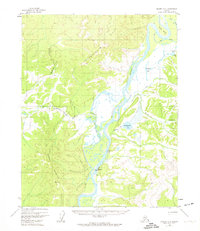
 2016 Hughes A-3 SE2016 Print · USGSThe settlement of Hughes sits along the Koyukuk River in this 2016 survey of the Alaska interior. Researchers can trace the local road network and river features like Hughes Bar and Klalbaimunket Lake.
 - 2016 Map of Hughes A-3 SW, 2016 Print
 2016 Hughes A-3 SW2016 Print · USGSThe Koyukuk River flows past the village of Hughes in this 2016 survey of interior Alaska. Researchers can trace the local landscape from the Hughes Airport up to the heights of Hughes Mtn and the depths of Hatdolitna Canyon.
End of results
Showing maps 1-8 of 8
Frequently asked questions
- What are the different types of historical maps available for Hughes?
- What is the oldest map of Hughes?
- Where can I purchase historical maps of Hughes for my home or office?
- Where can I download high-res historical maps of Hughes?
- Are there historical topographic maps available for Hughes?
- Is there historical aerial imagery available for Hughes?
- Where are historical maps of Hughes sourced from?