Old Maps of Huslia, Alaska for Metal Detecting
Plan your next treasure hunt with 4 historic maps of Huslia. Find old homesites, ghost towns, trails, and gathering spots that may be lost to time — perfect for identifying promising metal detecting locations.
- Locate forgotten sites: Uncover places like long-lost settlements, abandoned rail lines, or gathering spots.
- Plan better hunts: Use map overlays combined with LiDAR or satellite views to narrow in on historically rich areas.
- Made for detectorists: Thousands of hobbyists use these maps to discover relics, coins, and hidden history.
Use these historic maps to boost your research and find new opportunities beneath the surface of Huslia.
Huslia, AK maps
(4)- 1951 Map of Kateel River
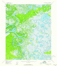
 1951 Kateel River1951 Print · USGSThe Yukon-Koyukuk region in the early fifties shows a landscape defined by seasonal water and remote commerce. Researchers can trace historic river navigation and early outposts like Cutoff Trading Post, Nikolai Slough, and the isolated Trading Post.
 - 1954 Map of Kateel River C-1, 1959 Print
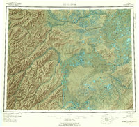
 1954 Kateel River C-11959 Print · USGSThe interior of Alaska along the Koyukuk River is captured here in the mid-1950s, showing a landscape of seasonal trails and river-dependent settlements. Researchers can locate remote outposts like Richards Camp and Simons Cabin or trace the path of the Winter Trail through the wetlands.3 unique versions available
 - 1955 Map of Kateel River, 1959 Print
 1955 Kateel River1959 Print · USGSThe interior of Alaska during the mid-fifties reveals a landscape of winding river systems and isolated riverbank settlements. Researchers can trace the river-based economy of the day through the Old Cutoff Trading Post, Huslia, and numerous sites like Fishing Camp.6 unique versions available
 - 2016 Map of Kateel River C-1 NW, 2016 Print
 2016 Kateel River C-1 NW2016 Print · USGSThe village of Huslia stands along the winding Koyukuk River in this modern survey of Alaska's interior. Genealogists and researchers can trace the local infrastructure, from the Huslia Airport to secondary routes like Lona Lake Road.
End of results
Showing maps 1-4 of 4
Frequently asked questions
- What are the different types of historical maps available for Huslia?
- What is the oldest map of Huslia?
- Where can I purchase historical maps of Huslia for my home or office?
- Where can I download high-res historical maps of Huslia?
- Are there historical topographic maps available for Huslia?
- Is there historical aerial imagery available for Huslia?
- Where are historical maps of Huslia sourced from?