Old Maps of Igiak, Alaska for Genealogy
Trace your family roots with 5 historic maps of Igiak. These high-res maps reveal old neighborhoods, homesites, landmarks, and streets — helping you uncover where your ancestors lived and how the area evolved over time.
- Explore historic neighborhoods: Identify where your relatives may have lived in the 1800s or 1900s.
- Compare maps over time: Trace the changes in streets, buildings, and landmarks for multi-generational research.
- Perfect for genealogy & ancestry research: Used by family historians and researchers to map out lineage and migration.
These maps are an incredible resource for exploring your personal connection to Igiak's past.
Igiak, AK maps
(5)- 1951 Map of Hooper Bay
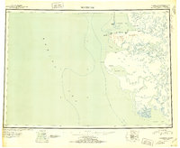 1951 Hooper Bay1951 Print · USGSThe Yukon-Kuskokwim Delta coast is captured here just after the war, showing the remote settlements and river systems of the Bering Sea. You can trace the Winter Trail between Scammon Bay and Kutmiut or locate the old landing at Hooper Bay.
 - 1952 Map of Hooper Bay C-3, 1959 Print
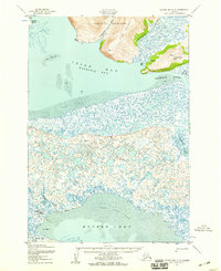 1952 Hooper Bay C-31959 Print · USGSCoastal Alaska in the early fifties is defined here by the intricate delta landscape of Igiak Bay and the village of Hooper Bay. Researchers can trace old coastal infrastructure and sites including the settlement at Paimiut, a cemetery, and the Nuok Spit coastline.3 unique versions available
 - 1953 Map of Hooper Bay, 1963 Print
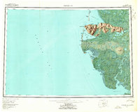 1953 Hooper Bay1963 Print · USGSThe Bering Sea coast near the Yukon-Kuskokwim Delta appears here in the early fifties, showing a land of tidal rivers and tundra. Trace the locations of Hooper Bay, Chevak, and Old Chevak alongside the prominent As Kinuk Mountains.5 unique versions available
 - 1964 Map of Hooper Bay
 1964 Hooper Bay1964 Print · USGSCoastal Alaska's Yukon-Kuskokwim Delta is captured in the mid-sixties, a time when river travel and seasonal settlements defined the region. Genealogists and historians can trace the foundations of Hooper Bay and Chevak, or locate traditional sites like Paimiut and Old Chevak.
 - 2020 Map of Hooper Bay C-3 SE, 2020 Print
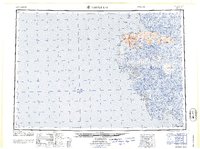
 2020 Hooper Bay C-3 SE2020 Print · USGSThe remote coastal tundra of the Kusilvak Census Area is captured here in the years following the turn of the century. Researchers can trace the winding course of Komoiarak Slough and the northern reaches of Hooper Bay across several uninhabited townships.
End of results
Showing maps 1-5 of 5
Top cities near Igiak
Frequently asked questions
- What are the different types of historical maps available for Igiak?
- What is the oldest map of Igiak?
- Where can I purchase historical maps of Igiak for my home or office?
- Where can I download high-res historical maps of Igiak?
- Are there historical topographic maps available for Igiak?
- Is there historical aerial imagery available for Igiak?
- Where are historical maps of Igiak sourced from?