Old Maps of Katalla, Alaska for Genealogy
Trace your family roots with 8 historic maps of Katalla. These high-res maps reveal old neighborhoods, homesites, landmarks, and streets — helping you uncover where your ancestors lived and how the area evolved over time.
- Explore historic neighborhoods: Identify where your relatives may have lived in the 1800s or 1900s.
- Compare maps over time: Trace the changes in streets, buildings, and landmarks for multi-generational research.
- Perfect for genealogy & ancestry research: Used by family historians and researchers to map out lineage and migration.
These maps are an incredible resource for exploring your personal connection to Katalla's past.
Katalla, AK maps
(8)- 1948 Map of Cordova, 1957 Print
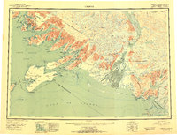
 1948 Cordova1957 Print · USGSCoastal Alaska in the late 1940s is defined by its deep-water inlets and the massive Copper River Delta. Genealogists and historians can trace old settlements like Katalla, Ellamar, and Nuchek alongside landmarks like the Cordova Airport.2 unique versions available
 - 1950 Map of Cordova A-2, 1964 Print
 1950 Cordova A-21964 Print · USGSThe Gulf of Alaska coastline near Katalla reflects a mid-century moment of industrial transition where early oil exploration met the wild Chugach coast. Researchers can trace the Old Railroad Grade and locate the historic Katalla Oil Field and its abandoned Refinery.4 unique versions available
 - 1951 Map of Cordova
 1951 Cordova1951 Print · USGSThe Gulf of Alaska shoreline comes alive in the early fifties, detailing the intricate fjords and coastal settlements of Prince William Sound. Genealogists and historians can trace the Copper River and Northwestern RR and locate sites like Katalla, Ellamar, and Nuchek.3 unique versions available
 - 1953 Map of Cordova A-2
 1953 Cordova A-21953 Print · USGSThe Katalla coast during the early fifties reveals a landscape of industrial transition within the Chugach National Forest. Trace the legacy of Alaska's first oil boom via the Katalla Oil Field, the Refinery, and the Old Railroad Grade.2 unique versions available
 - 1959 Map of Cordova, 1966 Print
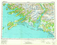 1959 Cordova1966 Print · USGSCoastal life and the industrial legacy of the Copper River region are frozen in time on this mid-century survey of Prince William Sound. Genealogists and historians can trace the route of the Copper River and Northwestern RR or locate old settlements like Katalla, Ellamar, and Alaganik.6 unique versions available
 - 1997 Map of Cordova A-2, 2000 Print
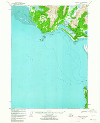
 1997 Cordova A-22000 Print · USGSThe Gulf of Alaska coast near Katalla was a site of pioneering industrial effort in the late twentieth century. Genealogists and industrial historians can trace the remnants of this era through labels for the Refinery, Ruins, and the Cem at Katalla.
 - 2014 Map of Cordova A-2 NE, 2014 Print
 2014 Cordova A-2 NE2014 Print · USGSCovers Katalla, including Unorganized Borough, United States, and other nearby areas
 - 2024 Map of Cordova A-2 NE, 2024 Print
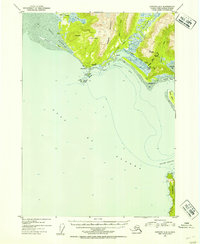
 2024 Cordova A-2 NE2024 Print · USGSThe Gulf of Alaska shoreline near Katalla is captured in this 2024 survey, showcasing the coastal interface between the mountains and the sea. Researchers can trace the drainage of the Katalla River into Katalla Bay and locate landmarks like Palm Point and Kanak Island.
End of results
Showing maps 1-8 of 8
Frequently asked questions
- What are the different types of historical maps available for Katalla?
- What is the oldest map of Katalla?
- Where can I purchase historical maps of Katalla for my home or office?
- Where can I download high-res historical maps of Katalla?
- Are there historical topographic maps available for Katalla?
- Is there historical aerial imagery available for Katalla?
- Where are historical maps of Katalla sourced from?