Old Maps of Klikitarik, Alaska for Academic Research
Study the evolution of Klikitarik with 5 high-resolution historic maps. Whether you're teaching, researching, or modeling changes in land use, these maps provide essential visual documentation of urban, environmental, and geographic change.
- Analyze long-term change: Track patterns in development, transportation, and natural features.
- Ideal for environmental or urban studies: Support academic projects with primary historical map data.
- Use in the classroom or lab: Educators and researchers rely on these maps to bring historical context to life.
These maps are a powerful tool for teaching, research, and visualizing how Klikitarik has changed over the decades.
Klikitarik, AK maps
(5)- 1951 Map of Unalakleet
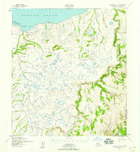
 1951 Unalakleet1951 Print · USGSWestern Alaska's coastal and river corridors are captured in the early 1950s, showing the vital connection between Norton Sound and the interior. Researchers can trace the Winter Trail networks and locate remote outposts like Golsovia and the Coal Mine near Unalakleet.
 - 1952 Map of Unalakleet B-5, 1959 Print
 1952 Unalakleet B-51959 Print · USGSCoastal Norton Sound and the Golsovia River valley are captured here in the early fifties, documenting a landscape shaped by seasonal travel and herding. Researchers can locate the Reindeer Corral near Klikitarik and trace the Winter Trail as it follows the northern bluffs.2 unique versions available
 - 1952 Map of Unalakleet, 1960 Print
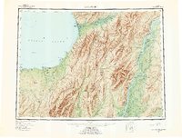 1952 Unalakleet1960 Print · USGSWestern Alaska in the early fifties shows a landscape of coastal settlements and interior river networks. Researchers can trace the Winter Trail and locate sites like the Williams Mine or the village of Unalakleet at the edge of the sound.8 unique versions available
 - 1964 Map of Unalakleet
 1964 Unalakleet1964 Print · USGSThe northern shores of Norton Sound and the interior Yukon River valley are documented here in the early sixties. Genealogists and researchers can trace remote outposts like Unalakleet, Golsovia, and the Williams Mine.
 - 2017 Map of Unalakleet B-5 NW, 2017 Print
 2017 Unalakleet B-5 NW2017 Print · USGSThe northern Alaskan coast near Norton Sound is captured here in the early twenty-first century, showing a remote landscape of rivers and hills. Researchers can trace the path of the Klikitarik River or locate coastal landmarks like Klikitarik and Toik Hill.
End of results
Showing maps 1-5 of 5
Frequently asked questions
- What are the different types of historical maps available for Klikitarik?
- What is the oldest map of Klikitarik?
- Where can I purchase historical maps of Klikitarik for my home or office?
- Where can I download high-res historical maps of Klikitarik?
- Are there historical topographic maps available for Klikitarik?
- Is there historical aerial imagery available for Klikitarik?
- Where are historical maps of Klikitarik sourced from?