
1952 Map of Unalakleet B-5
USGS Topo · Published 1959About this map
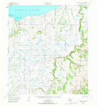
Klikitarik and the surrounding coastline of Klikitarik Bay define this mid-century survey of the Norton Sound region. The landscape is marked by a traditional subsistence economy and seasonal travel routes, most notably evidenced by a Reindeer Corral positioned near the coast and the Winter Trail that weaves along the northern bluffs. The interior is characterized by a high concentration of small lakes and ponds across the tundra, drained by the Klikitarik River and Wagon Box Creek. Prominent elevations such as Tolk Hill, Oliver Hill, and Klikitarik Mountain provide landmarks above the low-lying wetlands. To the east, the Golsovia River cuts a deep, winding valley through the terrain, meeting the sea near the Tolukowuk Bluffs. This 1952 data, based on Army Map Service photogrammetry, captures the region at a time when traditional reindeer herding and winter overland travel were primary features of the local geography.
Find a feature on this map
17 named features on this map. Tap any name to fly to it.
Don’t see what you’re looking for? This feature index may not catch every label — zoom into the map to look around manually.
Map Details
Editions of this 1952 Unalakleet B-5 Map
2 editions found
Other maps of this area

1951 · Unalakleet
USGS Topo · 1:250,000

1952 · Unalakleet A-4
USGS Topo · 1:63,360

1952 · Unalakleet A-5
USGS Topo · 1:63,360

1952 · Unalakleet B-4
USGS Topo · 1:63,360

1952 · Unalakleet B-6
USGS Topo · 1:63,360

1952 · Unalakleet C-4
USGS Topo · 1:63,360
1952 · Unalakleet C-5
USGS Topo · 1:63,360

1952 · Unalakleet A-6
USGS Topo · 1:63,360

1952 · Unalakleet
USGS Topo · 1:250,000

1964 · Unalakleet
USGS Topo · 1:250,000