
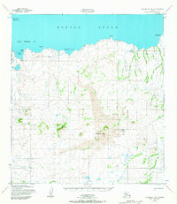
1952 Map of Unalakleet B-6
USGS Topo · Published 1959About this map
Norton Sound and the shoreline of Saint Michael Bay define this coastal subarctic landscape during the early 1950s. The interior is marked by significant volcanic activity, most notably the prominent peaks of The Sisters and expansive fields of Lava that spread across the central terrain. While much of the land remains wild, signs of human activity are present in the form of a Winter Trail (Approximate) and the remote Healy (Aban'd) settlement. Mariners of the era relied on the Whale Island Light on Whale Island to navigate into Liebes Cove and Eightmile Cove. This survey, compiled from 1951-1952 aerial photography, captures the precarious nature of coastal life where even a simple Cabin or a short-lived settlement like Healy served as vital landmarks in a demanding environment.
Find a feature on this map
14 named features on this map. Tap any name to fly to it.
Don’t see what you’re looking for? This feature index may not catch every label — zoom into the map to look around manually.
Map Details
Editions of this 1952 Unalakleet B-6 Map
2 editions found
Other maps of this area

1951 · Unalakleet
USGS Topo · 1:250,000

1951 · St Michael
USGS Topo · 1:250,000
1952 · Saint Michael C-1
USGS Topo · 1:63,360

1952 · Saint Michael B-1
USGS Topo · 1:63,360

1952 · Saint Michael A-1
USGS Topo · 1:63,360

1952 · Unalakleet A-5
USGS Topo · 1:63,360

1952 · Unalakleet B-5
USGS Topo · 1:63,360
1952 · Unalakleet C-5
USGS Topo · 1:63,360

1952 · Unalakleet A-6
USGS Topo · 1:63,360

1952 · St Michael
USGS Topo · 1:250,000