
1952 Map of Unalakleet A-4
USGS Topo · Published 1959About this map
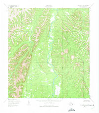
The Anvik River dominates this interior Alaskan landscape, meandering through a broad valley floor characterized by wetlands and braided stream channels. Surveyed in the early 1950s, the terrain shows a clear transition from the marshy lowlands of the river basin to the steep, unnamed ridges rising to the west. This 1:63,360 scale topographic study captures the hydrological network of the region, including the eastern confluence of Canyon Creek and the southern drainage of Runkels Creek. To the west, the Swift River parallels the main valley, carved into the higher elevations. The lack of established roads or structures in this area underscores the wilderness character of the Yukon-Koyukuk region during the mid-twentieth century, as documented by the Army Map Service using early photogrammetric methods.
Find a feature on this map
4 named features on this map. Tap any name to fly to it.
Don’t see what you’re looking for? This feature index may not catch every label — zoom into the map to look around manually.
Map Details
Editions of this 1952 Unalakleet A-4 Map
2 editions found
Other maps of this area

1951 · Unalakleet
USGS Topo · 1:250,000

1951 · Holy Cross
USGS Topo · 1:250,000

1952 · Unalakleet A-3
USGS Topo · 1:63,360

1952 · Unalakleet A-5
USGS Topo · 1:63,360

1952 · Unalakleet B-4
USGS Topo · 1:63,360

1952 · Holy Cross D-5
USGS Topo · 1:63,360

1952 · Holy Cross D-4
USGS Topo · 1:63,360

1952 · Holy Cross D-3
USGS Topo · 1:63,360

1952 · Unalakleet B-3
USGS Topo · 1:63,360

1952 · Unalakleet B-5
USGS Topo · 1:63,360