
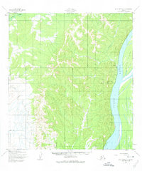
1952 Map of Holy Cross D-3
USGS Topo · Published 1959About this map
The Yukon River dominates the eastern edge of this mid-century survey, its massive channel carving through the interior landscape past Eagle Island. In the early 1950s, this area of Alaska remained largely wild, defined by drainage systems like Grayling Creek and the Yellow River in the northwest. Local human activity is concentrated along the riverbanks, where isolated Cabins and a designated Trail indicate the reliance on the river for travel and subsistence. This topographic study, mapped by the Army Map Service and published for civil use, illustrates the transition from the high, dissected hills in the interior toward the low-lying wetlands of the Yukon River valley, providing a clear record of the region's physical geography before modern infrastructure reached this part of the interior.
Find a feature on this map
7 named features on this map. Tap any name to fly to it.
Don’t see what you’re looking for? This feature index may not catch every label — zoom into the map to look around manually.
Map Details
Editions of this 1952 Holy Cross D-3 Map
2 editions found
Other maps of this area

1951 · Unalakleet
USGS Topo · 1:250,000

1951 · Holy Cross
USGS Topo · 1:250,000

1952 · Unalakleet A-2
USGS Topo · 1:63,360

1952 · Unalakleet A-4
USGS Topo · 1:63,360

1952 · Unalakleet A-3
USGS Topo · 1:63,360

1952 · Holy Cross C-2
USGS Topo · 1:63,360

1952 · Holy Cross D-4
USGS Topo · 1:63,360

1952 · Holy Cross D-2
USGS Topo · 1:63,360

1952 · Holy Cross C-3
USGS Topo · 1:63,360

1952 · Holy Cross C-4
USGS Topo · 1:63,360