
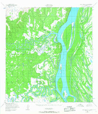
1952 Map of Holy Cross C-3
USGS Topo · Published 1959About this map
The confluence of the Anvik River and the Yukon River defines this sub-arctic landscape during the early 1950s. The settlement of Anvik sits prominently on the western bank of the Yukon, positioned near the dramatic rise of Hawk Bluff. This area serves as a critical junction for river travel and overland routes, as evidenced by the Winter Trail that cuts across the river islands and through the interior.
Find a feature on this map
12 named features on this map. Tap any name to fly to it.
Don’t see what you’re looking for? This feature index may not catch every label — zoom into the map to look around manually.
Map Details
Editions of this 1952 Holy Cross C-3 Map
2 editions found
Other maps of this area

1951 · Holy Cross
USGS Topo · 1:250,000

1952 · Holy Cross B-2
USGS Topo · 1:63,360

1952 · Holy Cross C-2
USGS Topo · 1:63,360

1952 · Holy Cross D-4
USGS Topo · 1:63,360

1952 · Holy Cross D-2
USGS Topo · 1:63,360

1952 · Holy Cross B-3
USGS Topo · 1:63,360

1952 · Holy Cross D-3
USGS Topo · 1:63,360

1952 · Holy Cross C-4
USGS Topo · 1:63,360

1952 · Holy Cross B-4
USGS Topo · 1:63,360

1952 · Holy Cross
USGS Topo · 1:250,000