
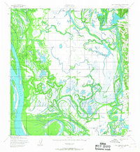
1952 Map of Holy Cross B-2
USGS Topo · Published 1959About this map
The Yukon River and Innoko River dominate this interior Alaskan landscape, creating a complex network of sloughs and wetlands where the two massive waterways converge. In the early 1950s, human presence was marked by small outposts such as Travis Cabins and several isolated Cabins scattered along the banks, reflecting the seasonal and subsistence-based lifestyle of the region. Overland travel during this era relied on a Winter Trail that paralleled the Yukon, providing a vital connection through the subarctic terrain when the ground and waters were frozen. Landforms like Carlo Island and the oxbow-formed Horseshoe Lake illustrate the constant shifting of these river systems, which served as the primary transit corridors for both indigenous people and early 20th-century settlers.
Find a feature on this map
7 named features on this map. Tap any name to fly to it.
Don’t see what you’re looking for? This feature index may not catch every label — zoom into the map to look around manually.
Map Details
Editions of this 1952 Holy Cross B-2 Map
2 editions found
Other maps of this area

1951 · Holy Cross
USGS Topo · 1:250,000

1952 · Holy Cross A-2
USGS Topo · 1:63,360

1952 · Holy Cross C-2
USGS Topo · 1:63,360

1952 · Holy Cross C-1
USGS Topo · 1:63,360

1952 · Holy Cross A-1
USGS Topo · 1:63,360

1952 · Holy Cross B-3
USGS Topo · 1:63,360

1952 · Holy Cross B-1
USGS Topo · 1:63,360

1952 · Holy Cross C-3
USGS Topo · 1:63,360

1952 · Holy Cross A-3
USGS Topo · 1:63,360

1952 · Holy Cross
USGS Topo · 1:250,000