
1952 Map of Holy Cross A-1
USGS Topo · Published 1959About this map
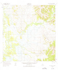
Paimiut Slough winds through the low-lying western portion of this 1952 survey, a complex network of wetlands and seasonal waterways characteristic of the Alaskan interior. The landscape transitions from the marshy expanses around Reindeer Lake and the meandering Reindeer River to the prominent rising elevations of Saddle Mountain in the east. This map, based on aerial photography from 1951 and 1952, documents the seasonal nature of travel in the region, noting a winter route and an approximate path across the tundra. The lack of permanent infrastructure highlight the area's isolation and the importance of natural water systems for navigation before significant modern development reached this part of the Holy Cross region.
Find a feature on this map
6 named features on this map. Tap any name to fly to it.
Don’t see what you’re looking for? This feature index may not catch every label — zoom into the map to look around manually.
Map Details
Editions of this 1952 Holy Cross A-1 Map
3 editions found

Other maps of this area

1947 · Russian Mission
USGS Topo · 1:250,000

1950 · Russian Mission
USGS Topo · 1:250,000

1950 · Sleetmute
USGS Topo · 1:250,000

1951 · Holy Cross
USGS Topo · 1:250,000

1951 · Iditarod
USGS Topo · 1:250,000

1952 · Holy Cross B-2
USGS Topo · 1:63,360

1952 · Holy Cross A-2
USGS Topo · 1:63,360

1952 · Holy Cross B-1
USGS Topo · 1:63,360

1952 · Russian Mission D-2
USGS Topo · 1:63,360

1952 · Holy Cross
USGS Topo · 1:250,000