
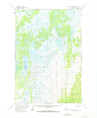
1952 Map of Russian Mission D-2
USGS Topo · Published 1960About this map
Paimiut sits at the northern edge of this 1950s survey, representing a concentrated point of human presence within an intricate network of waterways and wetlands. The landscape is defined by the winding course of the Paimiut Slough, which meanders through a vast expanse of lakes and marshland characteristic of this region. Mapping by the Geological Survey reveals a complex drainage pattern where land and water are constantly intertwined. The lack of roads or established trails throughout the quadrangle highlights the reliance on these natural water corridors for movement and subsistence. This era of mapping, based on 1951-1952 aerial photography, documents the untouched topography before significant modern changes, preserving the original land lines predetermined by the Bureau of Land Management.
Find a feature on this map
2 named features on this map. Tap any name to fly to it.
Don’t see what you’re looking for? This feature index may not catch every label — zoom into the map to look around manually.
Map Details
Editions of this 1952 Russian Mission D-2 Map
2 editions found
Other maps of this area

1947 · Russian Mission
USGS Topo · 1:250,000

1950 · Russian Mission
USGS Topo · 1:250,000

1951 · Holy Cross
USGS Topo · 1:250,000

1952 · Holy Cross A-2
USGS Topo · 1:63,360

1952 · Holy Cross A-1
USGS Topo · 1:63,360

1952 · Russian Mission C-1
USGS Topo · 1:63,360

1952 · Holy Cross
USGS Topo · 1:250,000

1952 · Russian Mission D-1
USGS Topo · 1:63,360

1952 · Russian Mission D-3
USGS Topo · 1:63,360

1952 · Russian Mission C-3
USGS Topo · 1:63,360