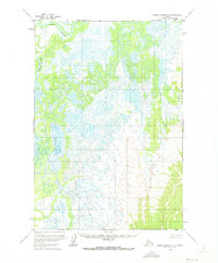
1952 Map of Russian Mission D-2
USGS Topo · Published 1973About this map
Paimiut Slough dominates the northwestern corner of this landscape, carving a winding path through an extensive network of wetlands and seasonal water bodies. Mapped from aerial photography taken in the early 1950s, the terrain represents the complex hydrological environment of the Bethel region before modern shifts in the river systems. The intricate web of smaller, unnamed lakes and marshy lowlands reflects a landscape defined by water and low relief, where travel and subsistence would have been dictated by the seasonal flow of the slough. While largely devoid of named settlements or infrastructure, the detailed mapping of the wetter areas provides a precise record of the natural drainage patterns that have historically shaped this part of the Alaskan interior.
Find a feature on this map
1 named feature on this map. Tap any name to fly to it.
Don’t see what you’re looking for? This feature index may not catch every label — zoom into the map to look around manually.
Map Details
Editions of this 1952 Russian Mission D-2 Map
2 editions found
Other maps of this area

1947 · Russian Mission
USGS Topo · 1:250,000

1950 · Russian Mission
USGS Topo · 1:250,000

1951 · Holy Cross
USGS Topo · 1:250,000

1952 · Holy Cross A-2
USGS Topo · 1:63,360

1952 · Holy Cross A-1
USGS Topo · 1:63,360

1952 · Russian Mission D-2
USGS Topo · 1:63,360

1952 · Russian Mission C-1
USGS Topo · 1:63,360

1952 · Holy Cross
USGS Topo · 1:250,000

1952 · Russian Mission D-1
USGS Topo · 1:63,360

1952 · Russian Mission D-3
USGS Topo · 1:63,360