
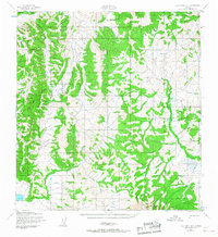
1952 Map of Holy Cross B-1
USGS Topo · Published 1959About this map
Winter transportation routes dictate the layout of this interior landscape as it was documented in the early 1950s. The region is defined by complex topography and a network of seasonal routes, including the primary Winter Trail and segments marked as Winter Trail (Approximate). These paths represent the essential overland corridors used when the ground and waterways were frozen, allowing movement through terrain that would otherwise be difficult to traverse. Mapped through aerial photography by the Army Map Service, the sheet provides a precise look at the drainage patterns and elevation changes of this unpopulated area during a period of systematic territorial surveying by the U.S. Geological Survey and the Corps of Engineers.
Find a feature on this map
2 named features on this map. Tap any name to fly to it.
Don’t see what you’re looking for? This feature index may not catch every label — zoom into the map to look around manually.
Map Details
Editions of this 1952 Holy Cross B-1 Map
2 editions found
Other maps of this area

1951 · Holy Cross
USGS Topo · 1:250,000

1951 · Iditarod
USGS Topo · 1:250,000

1952 · Holy Cross B-2
USGS Topo · 1:63,360

1952 · Holy Cross A-2
USGS Topo · 1:63,360

1952 · Holy Cross C-2
USGS Topo · 1:63,360

1952 · Holy Cross C-1
USGS Topo · 1:63,360

1952 · Holy Cross A-1
USGS Topo · 1:63,360

1952 · Holy Cross
USGS Topo · 1:250,000

1954 · Iditarod A-6
USGS Topo · 1:63,360
1954 · Iditarod C-6
USGS Topo · 1:63,360