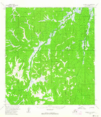
1954 Map of Iditarod C-6
USGS Topo · Published 1964About this map
The Big Yetna River and the Little Yetna River dominate this interior Alaskan landscape as it was documented in the early 1950s. The terrain is defined by complex river meanders and extensive marshlands, illustrating the difficult geography of the Yukon-Koyukuk region. Evidence of human passage and temporary settlement is sparse but significant, represented by a Winter Trail cutting through the wilderness and a Cabin (Aband) located near the western edge of the survey. The inclusion of the Vabm 747 vertical angle benchmark reflects the precise surveying work conducted by the Geological Survey during this era. This map captures a moment when travel in this area relied heavily on seasonal trails and the natural corridors provided by the river systems, before modern infrastructure altered the reach of the interior.
Find a feature on this map
5 named features on this map. Tap any name to fly to it.
Don’t see what you’re looking for? This feature index may not catch every label — zoom into the map to look around manually.
Map Details
Editions of this 1954 Iditarod C-6 Map
This is the sole edition of this map. No revisions or reprints were ever made.
Other maps of this area

1951 · Holy Cross
USGS Topo · 1:250,000

1951 · Iditarod
USGS Topo · 1:250,000

1952 · Holy Cross C-1
USGS Topo · 1:63,360

1952 · Holy Cross B-1
USGS Topo · 1:63,360

1952 · Holy Cross D-1
USGS Topo · 1:63,360

1952 · Holy Cross
USGS Topo · 1:250,000

1954 · Iditarod D-6
USGS Topo · 1:63,360

1954 · Iditarod B-5
USGS Topo · 1:63,360

1954 · Iditarod C-5
USGS Topo · 1:63,360

1954 · Iditarod D-5
USGS Topo · 1:63,360