
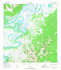
1952 Map of Holy Cross D-1
USGS Topo · Published 1959About this map
The Innoko River meanders through a vast network of wetlands and shifting channels in this 1952 topographic study. This remote portion of Alaska, mapped by the Army Map Service and published by the U.S. Geological Survey, showcases a complex riparian landscape defined by features like Holikachuk Slough. The geography is primarily a mix of dense low-lying marshes and rising upland terrain, punctuated by survey markers such as VABM Chalet and VABM Innoko. The intricate detail of the river’s oxbows and seasonal water patterns suggests a landscape defined more by hydrological cycles than permanent human infrastructure at the time of the survey. Researchers of Alaska’s interior will find the precise elevation contours and watercourse paths essential for understanding the historical physical geography of the Yukon-Koyukuk region before contemporary ecological changes.
Find a feature on this map
4 named features on this map. Tap any name to fly to it.
Don’t see what you’re looking for? This feature index may not catch every label — zoom into the map to look around manually.
Map Details
Editions of this 1952 Holy Cross D-1 Map
2 editions found
Other maps of this area

1951 · Ophir
USGS Topo · 1:250,000

1951 · Unalakleet
USGS Topo · 1:250,000

1951 · Holy Cross
USGS Topo · 1:250,000

1951 · Iditarod
USGS Topo · 1:250,000

1952 · Unalakleet A-2
USGS Topo · 1:63,360

1952 · Unalakleet A-1
USGS Topo · 1:63,360

1952 · Holy Cross C-2
USGS Topo · 1:63,360

1952 · Holy Cross C-1
USGS Topo · 1:63,360

1952 · Holy Cross D-2
USGS Topo · 1:63,360

1952 · Unalakleet
USGS Topo · 1:250,000