
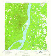
1952 Map of Unalakleet A-2
USGS Topo · Published 1953About this map
The Yukon River dominates this mid-century Alaskan landscape, its wide channel cutting through the interior wilderness south of the South Boundary Kateel River Meridian. The map captures a complex system of waterways, most notably Shageluk Slough and the braided channels surrounding Fox Point Island. This 1952 record shows the area's early reliance on seasonal transport routes, including a Winter Trail that winds through the lowlands between Thompson Creek and the riverbanks. Human presence is limited to scattered outposts, with a simple Cabin and multiple Cabins marked near the junctions of Simon Creek and Saint Joe Creek. These sites represent the vital staging points for hunters, trappers, and travelers navigating the river system before the era of modern development, providing essential geographic data for the Yukon-Koyukuk region.
Find a feature on this map
12 named features on this map. Tap any name to fly to it.
Don’t see what you’re looking for? This feature index may not catch every label — zoom into the map to look around manually.
Map Details
Editions of this 1952 Unalakleet A-2 Map
2 editions found
Other maps of this area

1951 · Unalakleet
USGS Topo · 1:250,000

1951 · Holy Cross
USGS Topo · 1:250,000

1952 · Unalakleet A-3
USGS Topo · 1:63,360

1952 · Unalakleet A-1
USGS Topo · 1:63,360

1952 · Holy Cross D-2
USGS Topo · 1:63,360

1952 · Holy Cross D-3
USGS Topo · 1:63,360

1952 · Holy Cross D-1
USGS Topo · 1:63,360

1952 · Unalakleet B-3
USGS Topo · 1:63,360

1952 · Unalakleet B-2
USGS Topo · 1:63,360

1952 · Unalakleet B-1
USGS Topo · 1:63,360