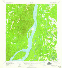
1952 Map of Unalakleet A-2
USGS Topo · Published 1959About this map
The Yukon River dominates this landscape as it flows through the interior of Alaska, flanked by complex waterways like the Shageluk Slough and Sucker Creek. Mapped in the early 1950s, this area shows the essential transportation routes of the era, most notably a Winter Trail cutting across the lowlands. The presence of isolated Cabin and Cabins sites along the riverbanks reflects a remote pattern of subsistence and seasonal residence common to this portion of the Yukon-Koyukuk region. Large features such as Fox Point Island break the wide course of the river, while smaller tributaries like Saint Joe Creek and Simon Creek drain the surrounding hills. This survey provides a record of the river's precise channels and drainage patterns before later environmental changes, capturing a moment when travel relied heavily on seasonal trails and the river system itself.
Find a feature on this map
12 named features on this map. Tap any name to fly to it.
Don’t see what you’re looking for? This feature index may not catch every label — zoom into the map to look around manually.
Map Details
Editions of this 1952 Unalakleet A-2 Map
2 editions found
Other maps of this area

1951 · Unalakleet
USGS Topo · 1:250,000

1951 · Holy Cross
USGS Topo · 1:250,000

1952 · Unalakleet A-2
USGS Topo · 1:63,360

1952 · Unalakleet A-3
USGS Topo · 1:63,360

1952 · Unalakleet A-1
USGS Topo · 1:63,360

1952 · Holy Cross D-2
USGS Topo · 1:63,360

1952 · Holy Cross D-3
USGS Topo · 1:63,360

1952 · Holy Cross D-1
USGS Topo · 1:63,360

1952 · Unalakleet B-3
USGS Topo · 1:63,360

1952 · Unalakleet B-2
USGS Topo · 1:63,360