
1952 Map of Unalakleet B-2
USGS Topo · Published 1959About this map
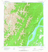
The Yukon River dominates this mid-century survey, carving a wide path through the Alaskan interior where Alice Island and Blackburn Island divide the current. Along the eastern bank, the settlement of Blackburn (Aban'd) is noted as already abandoned by the early 1950s, serving as a reminder of the shifting nature of river-based commerce and settlement in this remote region. Isolated Cabin and Cabins are scattered near the shoreline, indicating the small-scale human presence tied to the water.
Find a feature on this map
15 named features on this map. Tap any name to fly to it.
Don’t see what you’re looking for? This feature index may not catch every label — zoom into the map to look around manually.
Map Details
Editions of this 1952 Unalakleet B-2 Map
2 editions found
Other maps of this area

1951 · Unalakleet
USGS Topo · 1:250,000

1952 · Unalakleet A-2
USGS Topo · 1:63,360

1952 · Unalakleet A-3
USGS Topo · 1:63,360

1952 · Unalakleet C-2
USGS Topo · 1:63,360

1952 · Unalakleet A-1
USGS Topo · 1:63,360

1952 · Unalakleet C-3
USGS Topo · 1:63,360

1952 · Unalakleet B-3
USGS Topo · 1:63,360

1952 · Unalakleet C-1
USGS Topo · 1:63,360

1952 · Unalakleet B-1
USGS Topo · 1:63,360

1952 · Unalakleet
USGS Topo · 1:250,000