
1952 Map of Unalakleet C-1
USGS Topo · Published 1959About this map
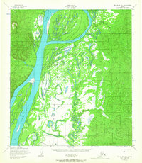
The Yukon River dominates this mid-century survey, creating a complex landscape of islands and braided waterways in the Alaska Interior. Large landforms like Bullfrog Island and Eagle Island are defined by the main channel and secondary paths like Honeymoon Slough. Human presence is sparse and concentrated along the riverbanks, represented by seasonal or subsistence outposts including Andrew Johnson Camp and several small Cabin sites. The interior is largely roadless, relying on the seasonal Winter Trail for overland movement when the marshy ground near Papa Willie Creek freezes. This map documents a traditional transportation corridor where the river serves as the primary artery for travel and resource access, long before significant modern infrastructure reached this portion of the Fourth Judicial Division.
Find a feature on this map
11 named features on this map. Tap any name to fly to it.
Don’t see what you’re looking for? This feature index may not catch every label — zoom into the map to look around manually.
Map Details
Editions of this 1952 Unalakleet C-1 Map
2 editions found
Other maps of this area

1951 · Ophir
USGS Topo · 1:250,000

1951 · Unalakleet
USGS Topo · 1:250,000

1952 · Unalakleet C-2
USGS Topo · 1:63,360

1952 · Unalakleet D-2
USGS Topo · 1:63,360

1952 · Unalakleet B-2
USGS Topo · 1:63,360

1952 · Unalakleet B-1
USGS Topo · 1:63,360

1952 · Unalakleet D-1
USGS Topo · 1:63,360

1952 · Unalakleet
USGS Topo · 1:250,000
1954 · Ophir D-6
USGS Topo · 1:63,360

1954 · Ophir C-6
USGS Topo · 1:63,360