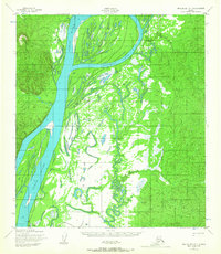
1952 Map of Unalakleet C-1
USGS Topo · Published 1967About this map
The Yukon River dominates this landscape, weaving around large alluvial landforms such as Bullfrog Island and Eagle Island. Mapped in the early 1950s, the terrain reveals a sparsely populated riverine environment where seasonal mobility was essential. Life and travel along the water are evidenced by the presence of Andrew Johnson Camp and Johnson Camp, as well as several isolated Cabins positioned near the riverbanks.
Find a feature on this map
16 named features on this map. Tap any name to fly to it.
Don’t see what you’re looking for? This feature index may not catch every label — zoom into the map to look around manually.
Map Details
Editions of this 1952 Unalakleet C-1 Map
2 editions found
Other maps of this area

1951 · Ophir
USGS Topo · 1:250,000

1951 · Unalakleet
USGS Topo · 1:250,000

1952 · Unalakleet C-2
USGS Topo · 1:63,360

1952 · Unalakleet D-2
USGS Topo · 1:63,360

1952 · Unalakleet C-1
USGS Topo · 1:63,360

1952 · Unalakleet B-2
USGS Topo · 1:63,360

1952 · Unalakleet B-1
USGS Topo · 1:63,360

1952 · Unalakleet D-1
USGS Topo · 1:63,360

1952 · Unalakleet
USGS Topo · 1:250,000
1954 · Ophir D-6
USGS Topo · 1:63,360