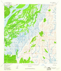
1954 Map of Ophir D-6
USGS Topo · Published 1960About this map
The Yukon River dominates the western corridor of this 1950s interior Alaska survey, weaving through a complex network of wetlands and riverine features. Large landmasses like Morgan Island and Quail Island are situated within the shifting channels, illustrating the dynamic hydrology of the region before significant modern development. To the east, the terrain rises sharply into the Kaiyuh Mountains, a distinctive upland system that provides a stark contrast to the saturated lowlands of the river valley. Mapping during this era relied heavily on 1953 aerial photography and subsequent field annotations to delineate the labyrinth of unnamed ponds and sloughs that feed into Stink Creek. The map is structured along the Kateel River Meridian, showing a landscape largely defined by its natural topography rather than human infrastructure or permanent settlements.
Find a feature on this map
6 named features on this map. Tap any name to fly to it.
Don’t see what you’re looking for? This feature index may not catch every label — zoom into the map to look around manually.
Map Details
Editions of this 1954 Ophir D-6 Map
This is the sole edition of this map. No revisions or reprints were ever made.
Other maps of this area

1945 · Nulato
USGS Topo · 1:250,000

1948 · Norton Bay
USGS Topo · 1:250,000

1951 · Ophir
USGS Topo · 1:250,000

1951 · Nulato
USGS Topo · 1:250,000

1951 · Unalakleet
USGS Topo · 1:250,000

1951 · Norton Bay
USGS Topo · 1:250,000

1952 · Nulato A-5
USGS Topo · 1:63,360

1952 · Nulato
USGS Topo · 1:250,000

1952 · Nulato A-6
USGS Topo · 1:63,360

1952 · Unalakleet C-1
USGS Topo · 1:63,360