
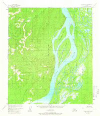
1952 Map of Nulato A-6
USGS Topo · Published 1958About this map
Big Eightmile Island and the smaller Little Eightmile Island dominate the braided channel of the Yukon River as it flows through the Alaska-Fourth Judicial Division in the early 1950s. The landscape is characterized by the complex interaction between the main river and the meandering Khotol River, which winds through the eastern wetlands. Human presence is sparse, marked only by isolated Cabin and Cabins structures along the riverbanks, suggesting seasonal use for trapping or fishing. The western terrain rises sharply from the river valley toward inland heights, punctuated by the survey marker at VABM Kayak 1427. Small tributaries like Rado Creek and Poison Creek drain the western uplands, feeding into the massive Yukon system. This survey represents a remote wilderness before significant modern development, emphasizing the natural waterway corridors that historically served as the primary routes for movement through the interior.
Find a feature on this map
10 named features on this map. Tap any name to fly to it.
Don’t see what you’re looking for? This feature index may not catch every label — zoom into the map to look around manually.
Map Details
Editions of this 1952 Nulato A-6 Map
2 editions found
Other maps of this area

1945 · Nulato
USGS Topo · 1:250,000

1948 · Norton Bay
USGS Topo · 1:250,000

1951 · Ophir
USGS Topo · 1:250,000

1951 · Nulato
USGS Topo · 1:250,000

1951 · Unalakleet
USGS Topo · 1:250,000

1951 · Norton Bay
USGS Topo · 1:250,000

1952 · Nulato A-5
USGS Topo · 1:63,360

1952 · Nulato B-6
USGS Topo · 1:63,360

1952 · Norton Bay B-1
USGS Topo · 1:63,360

1952 · Nulato B-5
USGS Topo · 1:63,360