
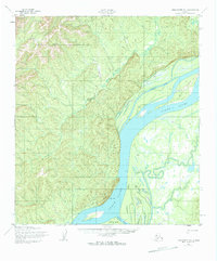
1952 Map of Unalakleet D-1
USGS Topo · Published 1959About this map
The Yukon River dominates this interior Alaska landscape, carving a wide path through a network of shifting waterways and dramatic terrain. In the early 1950s, the river’s complex morphology is evident in the presence of Steamboat Slough and Honeymoon Slough, which bypass central islands like Bullfrog Island. The map records a critical boundary point where the Second Judicial Division meets the Fourth Judicial Division amidst the high ridges and steep slopes. Landforms such as Eagle Slide overlook the riverbank, highlighting the dynamic nature of the river valley. Human passage through this wilderness is marked by the Winter Trail, a seasonal route typical of the era's transport network before more permanent infrastructure reached this part of the territory. The convergence of Stink Creek and Sajak Creek into the main river system illustrates the dense drainage pattern of the surrounding uplands.
Find a feature on this map
10 named features on this map. Tap any name to fly to it.
Don’t see what you’re looking for? This feature index may not catch every label — zoom into the map to look around manually.
Map Details
Editions of this 1952 Unalakleet D-1 Map
2 editions found
Other maps of this area

1945 · Nulato
USGS Topo · 1:250,000

1948 · Norton Bay
USGS Topo · 1:250,000

1951 · Ophir
USGS Topo · 1:250,000

1951 · Nulato
USGS Topo · 1:250,000

1951 · Unalakleet
USGS Topo · 1:250,000

1951 · Norton Bay
USGS Topo · 1:250,000

1952 · Nulato
USGS Topo · 1:250,000

1952 · Nulato A-6
USGS Topo · 1:63,360

1952 · Unalakleet C-2
USGS Topo · 1:63,360

1952 · Unalakleet D-2
USGS Topo · 1:63,360