
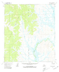
1954 Map of Ophir C-6
USGS Topo · Published 1965About this map
The Kaiyuh Mountains dominate the western half of this sub-arctic landscape, providing a sharp topographic contrast to the low-lying wetlands that spread across the east. Surveyed in the mid-1950s using photogrammetric methods, this map reveals the intricate drainage patterns of the Kateel River Meridian region. The terrain transitions from the elevated ridges of the Kaiyuh range into a dense network of marshes and waterbodies fed by Hather Creek and Mevolt Creek. This area of the Yukon-Koyukuk reflects a wilderness environment shaped by seasonal drainage and glacial legacy, with no roads or trails recorded at the time of the field annotation. The placement of the meridian through this territory emphasizes the systematic effort by the Bureau of Land Management to organize and survey Alaska's interior during the post-war era.
Find a feature on this map
4 named features on this map. Tap any name to fly to it.
Don’t see what you’re looking for? This feature index may not catch every label — zoom into the map to look around manually.
Map Details
Editions of this 1954 Ophir C-6 Map
2 editions found
Other maps of this area

1951 · Ophir
USGS Topo · 1:250,000

1951 · Unalakleet
USGS Topo · 1:250,000

1952 · Unalakleet C-1
USGS Topo · 1:63,360

1952 · Unalakleet B-1
USGS Topo · 1:63,360

1952 · Unalakleet D-1
USGS Topo · 1:63,360

1952 · Unalakleet
USGS Topo · 1:250,000
1954 · Ophir D-6
USGS Topo · 1:63,360
1954 · Ophir D-5
USGS Topo · 1:63,360

1954 · Ophir C-5
USGS Topo · 1:63,360
1954 · Ophir B-6
USGS Topo · 1:63,360