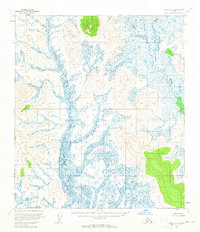
1954 Map of Ophir D-5
USGS Topo · Published 1965About this map
Little Mud River winds through the eastern portion of this 1950s interior Alaska landscape, dominated by a vast network of wetlands and complex drainage patterns. The terrain is defined by a dense concentration of swamps and muskeg, interpreted from aerial photographs to show the wettest areas of low relief. Flowing through the central lowlands, Dishkaket Creek carves a path between unnamed ridges that rise up to 1,000 feet. This 1954 survey represents the region before any established roads or trails were documented, reflecting a truly remote wilderness. The map details the unsurveyed and unmarked land lines as predetermined by the Bureau of Land Management, providing a look at the early administrative organization of the Kateel River Meridian.
Find a feature on this map
5 named features on this map. Tap any name to fly to it.
Don’t see what you’re looking for? This feature index may not catch every label — zoom into the map to look around manually.
Map Details
Editions of this 1954 Ophir D-5 Map
2 editions found
Other maps of this area

1945 · Nulato
USGS Topo · 1:250,000

1951 · Ophir
USGS Topo · 1:250,000

1951 · Nulato
USGS Topo · 1:250,000

1952 · Nulato A-5
USGS Topo · 1:63,360

1952 · Nulato A-4
USGS Topo · 1:63,360

1952 · Nulato
USGS Topo · 1:250,000

1952 · Nulato A-6
USGS Topo · 1:63,360
1953 · Nulato A-4
USGS Topo · 1:63,360
1954 · Ophir D-6
USGS Topo · 1:63,360

1954 · Ophir C-6
USGS Topo · 1:63,360