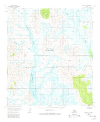
1954 Map of Ophir D-5
USGS Topo · Published 1982About this map
Magitchlie Creek and Roketatoi Creek dominate this 1950s landscape, which transitioned into the Innoko National Wildlife Refuge in later decades. The terrain is characterized by a dense network of wetlands and meandering waterways, typical of the interior Alaskan wilderness before modern development. Notable elevations include Peak No 7 1238, which provides one of the few prominent landmarks in a region largely defined by its intricate drainage patterns. To the east, the Little Mud River and its West Fork carve through the lowlands, illustrating the complex river systems that supported seasonal movements and ecological diversity. This map serves as a baseline for the region just as photogrammetric methods began to provide a comprehensive look at these remote areas, capturing the precise boundaries of what would become a protected federal refuge.
Find a feature on this map
7 named features on this map. Tap any name to fly to it.
Don’t see what you’re looking for? This feature index may not catch every label — zoom into the map to look around manually.
Map Details
Editions of this 1954 Ophir D-5 Map
2 editions found
Other maps of this area

1945 · Nulato
USGS Topo · 1:250,000

1951 · Ophir
USGS Topo · 1:250,000

1951 · Nulato
USGS Topo · 1:250,000

1952 · Nulato A-5
USGS Topo · 1:63,360

1952 · Nulato A-4
USGS Topo · 1:63,360

1952 · Nulato
USGS Topo · 1:250,000

1952 · Nulato A-6
USGS Topo · 1:63,360
1953 · Nulato A-4
USGS Topo · 1:63,360
1954 · Ophir D-6
USGS Topo · 1:63,360

1954 · Ophir C-6
USGS Topo · 1:63,360