
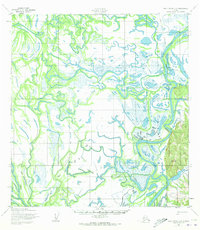
1952 Map of Holy Cross C-2
USGS Topo · Published 1959About this map
The Innoko River dominates this mid-century landscape, carving a complex network of meanders and oxbows through the Alaskan interior. In 1952, the settlement patterns here were defined by the water and the seasons, centered around the village of Shageluk and nearby Shageluk Lake. The map reveals the vital importance of seasonal mobility in this region, marking a lengthy Winter Trail and several scattered Cabins that served as essential outposts for subsistence and travel. This survey, based on aerial photography from 1951, captures the intricate hydrology of the floodplains before modern infrastructure reached the area, preserving the exact routes of the Winter Trail as they existed during the early post-war era.
Find a feature on this map
6 named features on this map. Tap any name to fly to it.
Don’t see what you’re looking for? This feature index may not catch every label — zoom into the map to look around manually.
Map Details
Editions of this 1952 Holy Cross C-2 Map
2 editions found
Other maps of this area

1951 · Holy Cross
USGS Topo · 1:250,000

1952 · Holy Cross B-2
USGS Topo · 1:63,360

1952 · Holy Cross C-1
USGS Topo · 1:63,360

1952 · Holy Cross D-2
USGS Topo · 1:63,360

1952 · Holy Cross B-3
USGS Topo · 1:63,360

1952 · Holy Cross D-3
USGS Topo · 1:63,360

1952 · Holy Cross B-1
USGS Topo · 1:63,360

1952 · Holy Cross D-1
USGS Topo · 1:63,360

1952 · Holy Cross C-3
USGS Topo · 1:63,360

1952 · Holy Cross
USGS Topo · 1:250,000