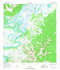
1952 Map of Holy Cross D-1
USGS Topo · Published 1967About this map
The Innoko River winds through a complex network of wetlands and shifting channels in this mid-century Alaskan interior survey. The terrain is characterized by the expansive alluvial flats of the river valley, where the Holikachuk Slough branches away from the main current. This landscape reflects a period of aerial mapping conducted by the Army Map Service, relying on photogrammetric methods from 1951 to chart the difficult-to-access western reaches of the state. Surveyors established critical triangulation points such as VABM Chalet 1032 and ABM Innoko 630 to anchor the topography. The map also delineates the Kateel River Meridian boundary, marking the intersection of public land survey systems in a region defined more by its watercourses than by human infrastructure.
Find a feature on this map
5 named features on this map. Tap any name to fly to it.
Don’t see what you’re looking for? This feature index may not catch every label — zoom into the map to look around manually.
Map Details
Editions of this 1952 Holy Cross D-1 Map
2 editions found
Other maps of this area

1951 · Ophir
USGS Topo · 1:250,000

1951 · Unalakleet
USGS Topo · 1:250,000

1951 · Holy Cross
USGS Topo · 1:250,000

1951 · Iditarod
USGS Topo · 1:250,000

1952 · Unalakleet A-2
USGS Topo · 1:63,360

1952 · Unalakleet A-1
USGS Topo · 1:63,360

1952 · Holy Cross C-2
USGS Topo · 1:63,360

1952 · Holy Cross C-1
USGS Topo · 1:63,360

1952 · Holy Cross D-2
USGS Topo · 1:63,360

1952 · Holy Cross D-1
USGS Topo · 1:63,360