
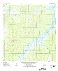
1954 Map of Iditarod A-6
USGS Topo · Published 1962About this map
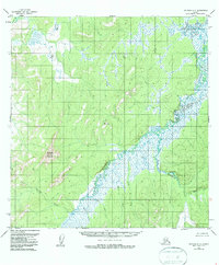
The Iditarod River anchors this interior Alaskan landscape, winding through a complex system of low-lying wetlands and creek drainages. Surveyed in the mid-1950s using photogrammetric methods from aerial photographs, the map reveals a wilderness shaped by water, where the main river channel is fed by numerous tributaries including American Creek, Little Creek, and Montana Creek. The terrain transitions from these saturated lowlands to significant high points in the west and central portions of the quadrangle. Mosquito Mountain and the survey station at VABM 1079 Montana provide the primary vertical relief. This document is a technical study of a region without established roads or permanent settlements at the time of the field annotation, documenting the natural drainage patterns of Slate Creek and Return Creek before any modern infrastructure altered the area.
Find a feature on this map
17 named features on this map. Tap any name to fly to it.
Don’t see what you’re looking for? This feature index may not catch every label — zoom into the map to look around manually.
Map Details
Editions of this 1954 Iditarod A-6 Map
3 editions found
Other maps of this area

1947 · Russian Mission
USGS Topo · 1:250,000

1950 · Russian Mission
USGS Topo · 1:250,000

1950 · Sleetmute
USGS Topo · 1:250,000

1951 · Holy Cross
USGS Topo · 1:250,000

1951 · Iditarod
USGS Topo · 1:250,000

1952 · Holy Cross A-1
USGS Topo · 1:63,360

1952 · Holy Cross B-1
USGS Topo · 1:63,360

1952 · Holy Cross
USGS Topo · 1:250,000

1952 · Russian Mission D-1
USGS Topo · 1:63,360
1954 · Sleetmute D-8
USGS Topo · 1:63,360