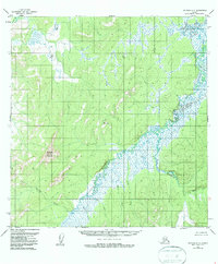
1954 Map of Iditarod A-6
USGS Topo · Published 1986About this map
The Iditarod River meanders through a landscape defined by expansive wetlands and high elevation points in the Yukon-Koyukuk region. Surveyed in the mid-1950s, this area shows the intricate drainage patterns of the Little Small Creek and Montana Creek as they feed into the primary river system. High points such as Mosquito Mountain and Vabm 1079 Montana serve as critical landmarks for surveying and navigation in this roadless territory. The map illustrates a wilderness characterized by marshy lowlands where American Creek and Reindeer R flow through undeveloped terrain. This documentation reflects the interior of Alaska before significant modern alterations, capturing the natural hydrological state of the Iditarod basin.
Find a feature on this map
10 named features on this map. Tap any name to fly to it.
Don’t see what you’re looking for? This feature index may not catch every label — zoom into the map to look around manually.
Map Details
Editions of this 1954 Iditarod A-6 Map
3 editions found

Other maps of this area

1947 · Russian Mission
USGS Topo · 1:250,000

1950 · Russian Mission
USGS Topo · 1:250,000

1950 · Sleetmute
USGS Topo · 1:250,000

1951 · Holy Cross
USGS Topo · 1:250,000

1951 · Iditarod
USGS Topo · 1:250,000

1952 · Holy Cross A-1
USGS Topo · 1:63,360

1952 · Holy Cross B-1
USGS Topo · 1:63,360

1952 · Holy Cross
USGS Topo · 1:250,000

1952 · Russian Mission D-1
USGS Topo · 1:63,360
1954 · Sleetmute D-8
USGS Topo · 1:63,360